You are here: Home > Network List > GE - GEOFON Stations List
> Station EIL GII/GEOFON Station Eilat, Israel > Earthquake Result Viewer
EIL GII/GEOFON Station Eilat, Israel - Earthquake Result Viewer
| Earthquake location: |
Windward Islands |
| Earthquake latitude/longitude: |
15.0/-61.3 |
| Earthquake time(UTC): |
2007/11/29 (333) 19:00:19 GMT |
| Earthquake Depth: |
148 km |
| Earthquake Magnitude: |
6.9 MB, 7.4 MW, 7.4 MW |
| Earthquake Catalog/Contributor: |
WHDF/NEIC |
|
| Network: |
GE GEOFON |
| Station: |
EIL GII/GEOFON Station Eilat, Israel |
| Lat/Lon: |
29.67 N/34.95 E |
| Elevation: |
210 m |
|
| Distance: |
88.0 deg |
| Az: |
59.968 deg |
| Baz: |
285.971 deg |
| Ray Param: |
0.04260368 |
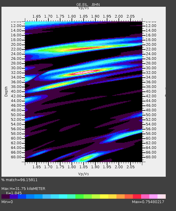
| Estimated Moho Depth: |
31.75 km |
| Estimated Crust Vp/Vs: |
1.85 |
| Assumed Crust Vp: |
6.472 km/s |
| Estimated Crust Vs: |
3.508 km/s |
| Estimated Crust Poisson's Ratio: |
0.29 |
|
| Radial Match: |
96.15911 % |
| Radial Bump: |
371 |
| Transverse Match: |
88.9137 % |
| Transverse Bump: |
398 |
| SOD ConfigId: |
2564 |
| Insert Time: |
2010-03-09 06:06:20.085 +0000 |
| GWidth: |
2.5 |
| Max Bumps: |
400 |
| Tol: |
0.001 |
|

Signal To Noise
| Channel | StoN | STA | LTA |
| GE:EIL: :BHN:20071129T19:12:21.738013Z | 10.358994 | 1.0766133E-5 | 1.039303E-6 |
| GE:EIL: :BHE:20071129T19:12:21.738013Z | 9.976597 | 1.6397533E-5 | 1.6435997E-6 |
| GE:EIL: :BHZ:20071129T19:12:21.712012Z | 23.426584 | 7.690417E-5 | 3.2827736E-6 |
| Arrivals |
| Ps | 4.2 SECOND |
| PpPs | 14 SECOND |
| PsPs/PpSs | 18 SECOND |


