You are here: Home > Network List > GE - GEOFON Stations List
> Station EIL GII/GEOFON Station Eilat, Israel > Earthquake Result Viewer
EIL GII/GEOFON Station Eilat, Israel - Earthquake Result Viewer
| Earthquake location: |
Java, Indonesia |
| Earthquake latitude/longitude: |
-8.2/112.4 |
| Earthquake time(UTC): |
1998/09/28 (271) 13:34:30 GMT |
| Earthquake Depth: |
152 km |
| Earthquake Magnitude: |
6.4 MB, 6.5 UNKNOWN, 6.5 MW |
| Earthquake Catalog/Contributor: |
WHDF/NEIC |
|
| Network: |
GE GEOFON |
| Station: |
EIL GII/GEOFON Station Eilat, Israel |
| Lat/Lon: |
29.67 N/34.95 E |
| Elevation: |
210 m |
|
| Distance: |
83.3 deg |
| Az: |
301.189 deg |
| Baz: |
103.336 deg |
| Ray Param: |
0.045955695 |
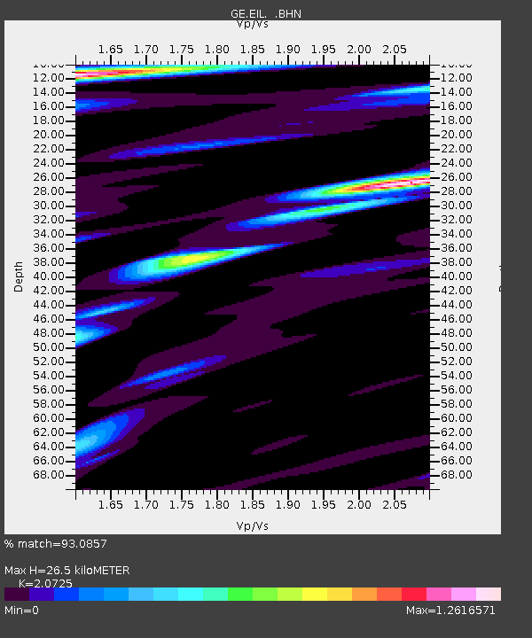
| Estimated Moho Depth: |
26.5 km |
| Estimated Crust Vp/Vs: |
2.07 |
| Assumed Crust Vp: |
6.472 km/s |
| Estimated Crust Vs: |
3.123 km/s |
| Estimated Crust Poisson's Ratio: |
0.35 |
|
| Radial Match: |
93.0857 % |
| Radial Bump: |
400 |
| Transverse Match: |
92.94213 % |
| Transverse Bump: |
400 |
| SOD ConfigId: |
4480 |
| Insert Time: |
2010-03-09 06:06:36.795 +0000 |
| GWidth: |
2.5 |
| Max Bumps: |
400 |
| Tol: |
0.001 |
|

Signal To Noise
| Channel | StoN | STA | LTA |
| GE:EIL: :BHN:19980928T13:46:08.816016Z | 13.932322 | 1.1919993E-6 | 8.55564E-8 |
| GE:EIL: :BHE:19980928T13:46:08.816016Z | 1.7842816 | 1.06003576E-7 | 5.9409665E-8 |
| GE:EIL: :BHZ:19980928T13:46:08.816016Z | 3.8514953 | 3.2390096E-7 | 8.4097465E-8 |
| Arrivals |
| Ps | 4.5 SECOND |
| PpPs | 12 SECOND |
| PsPs/PpSs | 17 SECOND |


