You are here: Home > Network List > TC - Red Sismólogica Nacional de Costa Rica Stations List
> Station MARA Maravilla > Earthquake Result Viewer
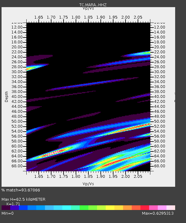
MARA Maravilla - Earthquake Result Viewer
| Earthquake location: |
Kermadec Islands Region |
| Earthquake latitude/longitude: |
-28.7/-176.6 |
| Earthquake time(UTC): |
2021/03/05 (064) 03:21:38 GMT |
| Earthquake Depth: |
10 km |
| Earthquake Magnitude: |
5.6 mb |
| Earthquake Catalog/Contributor: |
NEIC PDE/us |
|
| Network: |
TC Red Sismólogica Nacional de Costa Rica |
| Station: |
MARA Maravilla |
| Lat/Lon: |
10.02 N/85.43 W |
| Elevation: |
629 m |
|
| Distance: |
95.7 deg |
| Az: |
81.757 deg |
| Baz: |
242.011 deg |
| Ray Param: |
0.040719766 |
| Estimated Moho Depth: |
62.5 km |
| Estimated Crust Vp/Vs: |
1.71 |
| Assumed Crust Vp: |
6.597 km/s |
| Estimated Crust Vs: |
3.858 km/s |
| Estimated Crust Poisson's Ratio: |
0.24 |
|
| Radial Match: |
93.67866 % |
| Radial Bump: |
400 |
| Transverse Match: |
79.919075 % |
| Transverse Bump: |
400 |
| SOD ConfigId: |
23341671 |
| Insert Time: |
2021-03-19 04:34:00.757 +0000 |
| GWidth: |
2.5 |
| Max Bumps: |
400 |
| Tol: |
0.001 |
|

Signal To Noise
| Channel | StoN | STA | LTA |
| TC:MARA: :HHZ:20210305T03:34:32.929999Z | 1.2053866 | 1.1527598E-5 | 9.563403E-6 |
| TC:MARA: :HHN:20210305T03:34:32.929999Z | 1.1184685 | 1.0255495E-5 | 9.16923E-6 |
| TC:MARA: :HHE:20210305T03:34:32.929999Z | 1.1355639 | 1.1879591E-5 | 1.0461403E-5 |
| Arrivals |
| Ps | 6.9 SECOND |
| PpPs | 25 SECOND |
| PsPs/PpSs | 32 SECOND |


