You are here: Home > Network List > CC - Cascade Chain Volcano Monitoring Stations List
> Station CLBH Crater Lake, OR, USA > Earthquake Result Viewer
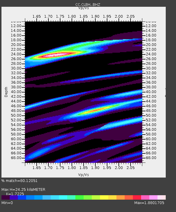
CLBH Crater Lake, OR, USA - Earthquake Result Viewer
| Earthquake location: |
Kermadec Islands Region |
| Earthquake latitude/longitude: |
-28.8/-176.6 |
| Earthquake time(UTC): |
2021/03/05 (064) 03:33:20 GMT |
| Earthquake Depth: |
10 km |
| Earthquake Magnitude: |
5.6 mb |
| Earthquake Catalog/Contributor: |
NEIC PDE/us |
|
| Network: |
CC Cascade Chain Volcano Monitoring |
| Station: |
CLBH Crater Lake, OR, USA |
| Lat/Lon: |
42.91 N/122.14 W |
| Elevation: |
2197 m |
|
| Distance: |
87.2 deg |
| Az: |
36.789 deg |
| Baz: |
225.686 deg |
| Ray Param: |
0.043530416 |
| Estimated Moho Depth: |
24.25 km |
| Estimated Crust Vp/Vs: |
1.72 |
| Assumed Crust Vp: |
6.522 km/s |
| Estimated Crust Vs: |
3.786 km/s |
| Estimated Crust Poisson's Ratio: |
0.25 |
|
| Radial Match: |
80.12051 % |
| Radial Bump: |
400 |
| Transverse Match: |
69.3955 % |
| Transverse Bump: |
400 |
| SOD ConfigId: |
23341671 |
| Insert Time: |
2021-03-19 04:41:38.937 +0000 |
| GWidth: |
2.5 |
| Max Bumps: |
400 |
| Tol: |
0.001 |
|

Signal To Noise
| Channel | StoN | STA | LTA |
| CC:CLBH: :BHZ:20210305T03:45:35.27498Z | 2.3955426 | 2.7633928E-6 | 1.1535561E-6 |
| CC:CLBH: :BHN:20210305T03:45:35.27498Z | 1.35076 | 2.4549295E-6 | 1.8174431E-6 |
| CC:CLBH: :BHE:20210305T03:45:35.27498Z | 1.2484307 | 3.6519502E-6 | 2.9252324E-6 |
| Arrivals |
| Ps | 2.8 SECOND |
| PpPs | 9.9 SECOND |
| PsPs/PpSs | 13 SECOND |


