You are here: Home > Network List > GE - GEOFON Stations List
> Station EIL GII/GEOFON Station Eilat, Israel > Earthquake Result Viewer
EIL GII/GEOFON Station Eilat, Israel - Earthquake Result Viewer
| Earthquake location: |
Eastern Siberia, Russia |
| Earthquake latitude/longitude: |
60.9/167.1 |
| Earthquake time(UTC): |
2006/04/20 (110) 23:25:02 GMT |
| Earthquake Depth: |
22 km |
| Earthquake Magnitude: |
6.8 MB, 7.6 MS, 7.6 MW, 7.3 MW |
| Earthquake Catalog/Contributor: |
WHDF/NEIC |
|
| Network: |
GE GEOFON |
| Station: |
EIL GII/GEOFON Station Eilat, Israel |
| Lat/Lon: |
29.67 N/34.95 E |
| Elevation: |
210 m |
|
| Distance: |
81.7 deg |
| Az: |
319.289 deg |
| Baz: |
21.456 deg |
| Ray Param: |
0.047400393 |
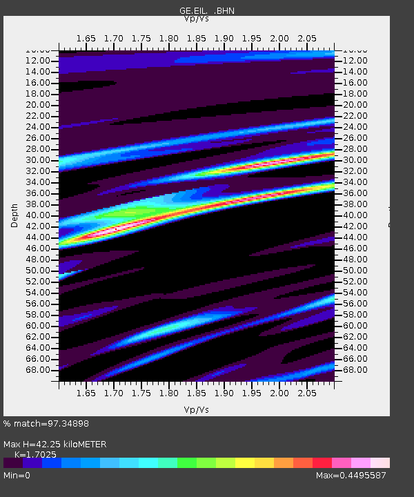
| Estimated Moho Depth: |
42.25 km |
| Estimated Crust Vp/Vs: |
1.70 |
| Assumed Crust Vp: |
6.472 km/s |
| Estimated Crust Vs: |
3.801 km/s |
| Estimated Crust Poisson's Ratio: |
0.24 |
|
| Radial Match: |
97.34898 % |
| Radial Bump: |
228 |
| Transverse Match: |
90.44306 % |
| Transverse Bump: |
400 |
| SOD ConfigId: |
2669 |
| Insert Time: |
2010-03-09 06:08:05.698 +0000 |
| GWidth: |
2.5 |
| Max Bumps: |
400 |
| Tol: |
0.001 |
|

Signal To Noise
| Channel | StoN | STA | LTA |
| GE:EIL: :BHN:20060420T23:36:47.288Z | 26.786146 | 3.1276108E-5 | 1.1676225E-6 |
| GE:EIL: :BHE:20060420T23:36:47.262Z | 22.241882 | 1.5314848E-5 | 6.8855906E-7 |
| GE:EIL: :BHZ:20060420T23:36:47.262Z | 47.750797 | 8.3392195E-5 | 1.7464042E-6 |
| Arrivals |
| Ps | 4.7 SECOND |
| PpPs | 17 SECOND |
| PsPs/PpSs | 22 SECOND |


