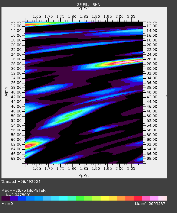
EIL GII/GEOFON Station Eilat, Israel - Earthquake Result Viewer

Earthquake location: Northern Sumatra, Indonesia
Earthquake latitude/longitude: 0.1/97.1
Earthquake time(UTC): 2006/05/16 (136) 15:28:25 GMT
Earthquake Depth: 12 km
Earthquake Magnitude: 6.6 MB, 6.8 MS, 6.8 MW, 6.8 MW
Earthquake Catalog/Contributor: WHDF/NEIC
Network: GE GEOFON
Station: EIL GII/GEOFON Station Eilat, Israel
Lat/Lon: 29.67 N/34.95 E
Elevation: 210 m
Distance: 65.9 deg
Az: 302.597 deg
Baz: 104.531 deg
Ray Param: 0.057952914
Estimated Moho Depth: 26.75 km
Estimated Crust Vp/Vs: 2.05
Assumed Crust Vp: 6.472 km/s
Estimated Crust Vs: 3.161 km/s
Estimated Crust Poisson's Ratio: 0.34
Radial Match: 96.492004 %
Radial Bump: 400
Transverse Match: 90.08524 %
Transverse Bump: 400
SOD ConfigId: 2669
Insert Time: 2010-03-09 06:08:16.394 +0000
GWidth: 2.5
Max Bumps: 400
Tol: 0.001

Signal To Noise

ChannelStoNSTALTA
GE:EIL: :BHN:20060516T15:38:40.412004Z5.9774388.178103E-61.3681617E-6
GE:EIL: :BHE:20060516T15:38:40.438005Z26.4330392.6723194E-51.010977E-6
GE:EIL: :BHZ:20060516T15:38:40.438005Z43.1230556.232064E-51.4451815E-6
Arrivals
Ps4.5 SECOND
PpPs12 SECOND
PsPs/PpSs17 SECOND