You are here: Home > Network List > IU - Global Seismograph Network (GSN - IRIS/USGS) Stations List
> Station JOHN Johnston Island, USA > Earthquake Result Viewer
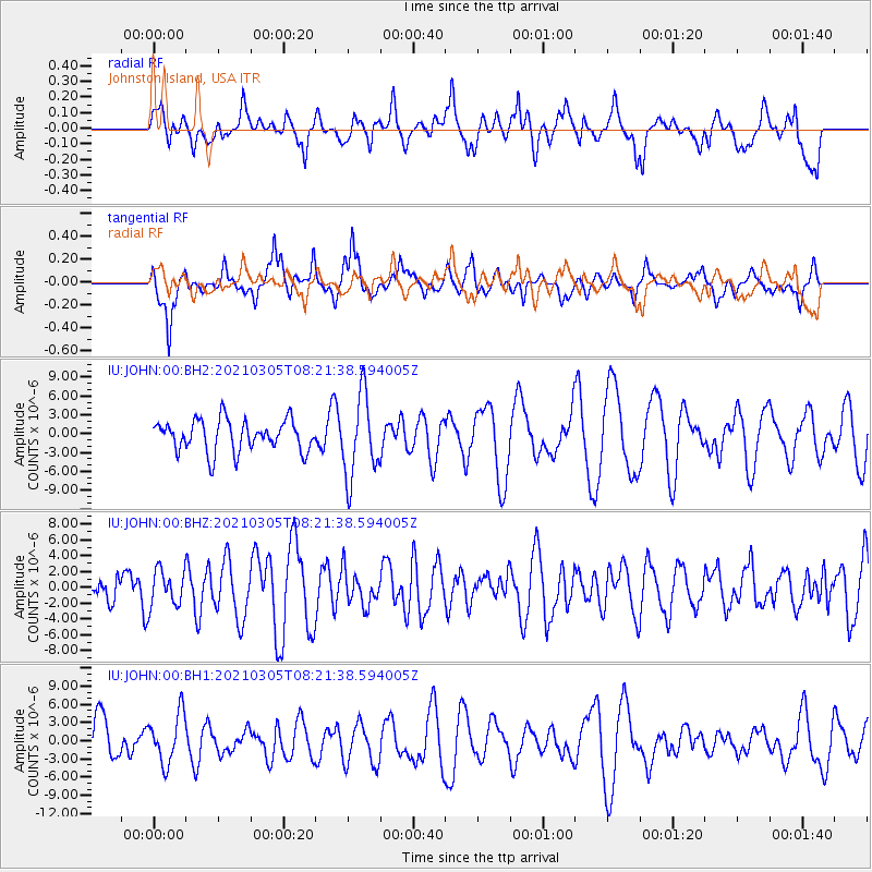
JOHN Johnston Island, USA - Earthquake Result Viewer
*The percent match for this event was below the threshold and hence no stack was calculated.
| Earthquake location: |
Kermadec Islands Region |
| Earthquake latitude/longitude: |
-29.4/-176.6 |
| Earthquake time(UTC): |
2021/03/05 (064) 08:13:42 GMT |
| Earthquake Depth: |
10 km |
| Earthquake Magnitude: |
5.6 mb |
| Earthquake Catalog/Contributor: |
NEIC PDE/us |
|
| Network: |
IU Global Seismograph Network (GSN - IRIS/USGS) |
| Station: |
JOHN Johnston Island, USA |
| Lat/Lon: |
16.73 N/169.53 W |
| Elevation: |
2.0 m |
|
| Distance: |
46.4 deg |
| Az: |
9.315 deg |
| Baz: |
188.473 deg |
| Ray Param: |
$rayparam |
*The percent match for this event was below the threshold and hence was not used in the summary stack. |
|
| Radial Match: |
55.57672 % |
| Radial Bump: |
400 |
| Transverse Match: |
59.721077 % |
| Transverse Bump: |
367 |
| SOD ConfigId: |
23341671 |
| Insert Time: |
2021-03-19 09:23:39.605 +0000 |
| GWidth: |
2.5 |
| Max Bumps: |
400 |
| Tol: |
0.001 |
|
Signal To Noise
| Channel | StoN | STA | LTA |
| IU:JOHN:00:BHZ:20210305T08:21:38.594005Z | 1.2639523 | 2.3039795E-6 | 1.8228374E-6 |
| IU:JOHN:00:BH1:20210305T08:21:38.594005Z | 1.0794599 | 4.0915183E-6 | 3.7903383E-6 |
| IU:JOHN:00:BH2:20210305T08:21:38.594005Z | 2.6316426 | 6.5511476E-6 | 2.489376E-6 |
| Arrivals |
| Ps | |
| PpPs | |
| PsPs/PpSs | |


