You are here: Home > Network List > TX - Texas Seismological Network Stations List
> Station 833A Chaparral WMA, Artesia Wells, TX, USA > Earthquake Result Viewer
833A Chaparral WMA, Artesia Wells, TX, USA - Earthquake Result Viewer
| Earthquake location: |
Kermadec Islands Region |
| Earthquake latitude/longitude: |
-29.4/-176.6 |
| Earthquake time(UTC): |
2021/03/05 (064) 08:13:42 GMT |
| Earthquake Depth: |
10 km |
| Earthquake Magnitude: |
5.6 mb |
| Earthquake Catalog/Contributor: |
NEIC PDE/us |
|
| Network: |
TX Texas Seismological Network |
| Station: |
833A Chaparral WMA, Artesia Wells, TX, USA |
| Lat/Lon: |
28.32 N/99.39 W |
| Elevation: |
171 m |
|
| Distance: |
93.4 deg |
| Az: |
59.442 deg |
| Baz: |
238.43 deg |
| Ray Param: |
0.04126812 |
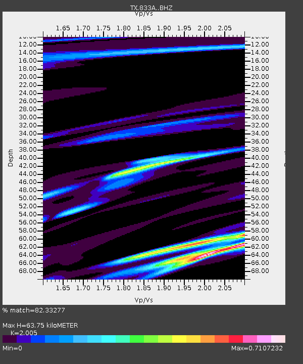
| Estimated Moho Depth: |
63.75 km |
| Estimated Crust Vp/Vs: |
2.01 |
| Assumed Crust Vp: |
6.347 km/s |
| Estimated Crust Vs: |
3.166 km/s |
| Estimated Crust Poisson's Ratio: |
0.33 |
|
| Radial Match: |
82.33277 % |
| Radial Bump: |
261 |
| Transverse Match: |
66.68935 % |
| Transverse Bump: |
400 |
| SOD ConfigId: |
23341671 |
| Insert Time: |
2021-03-19 09:27:39.361 +0000 |
| GWidth: |
2.5 |
| Max Bumps: |
400 |
| Tol: |
0.001 |
|

Signal To Noise
| Channel | StoN | STA | LTA |
| TX:833A: :BHZ:20210305T08:26:26.825023Z | 4.1185513 | 5.7929674E-7 | 1.4065544E-7 |
| TX:833A: :BHN:20210305T08:26:26.825023Z | 0.40627235 | 1.7156208E-7 | 4.2228345E-7 |
| TX:833A: :BHE:20210305T08:26:26.825023Z | 4.248655 | 4.0045282E-7 | 9.425403E-8 |
| Arrivals |
| Ps | 10 SECOND |
| PpPs | 30 SECOND |
| PsPs/PpSs | 40 SECOND |


