You are here: Home > Network List > AU - Australian Seismological Centre Stations List
> Station CMSA Cobar, New South Wales > Earthquake Result Viewer
CMSA Cobar, New South Wales - Earthquake Result Viewer
| Earthquake location: |
Kermadec Islands Region |
| Earthquake latitude/longitude: |
-29.1/-176.3 |
| Earthquake time(UTC): |
2021/03/05 (064) 14:24:49 GMT |
| Earthquake Depth: |
10 km |
| Earthquake Magnitude: |
6.2 Mww |
| Earthquake Catalog/Contributor: |
NEIC PDE/us |
|
| Network: |
AU Australian Seismological Centre |
| Station: |
CMSA Cobar, New South Wales |
| Lat/Lon: |
31.54 S/145.69 E |
| Elevation: |
220 m |
|
| Distance: |
32.8 deg |
| Az: |
256.096 deg |
| Baz: |
95.72 deg |
| Ray Param: |
0.07850766 |
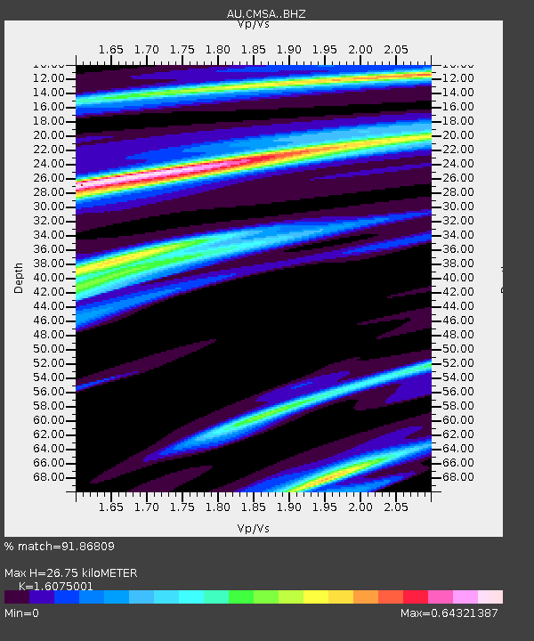
| Estimated Moho Depth: |
26.75 km |
| Estimated Crust Vp/Vs: |
1.61 |
| Assumed Crust Vp: |
6.522 km/s |
| Estimated Crust Vs: |
4.057 km/s |
| Estimated Crust Poisson's Ratio: |
0.18 |
|
| Radial Match: |
91.86809 % |
| Radial Bump: |
293 |
| Transverse Match: |
57.685524 % |
| Transverse Bump: |
356 |
| SOD ConfigId: |
23341671 |
| Insert Time: |
2021-03-19 15:29:02.817 +0000 |
| GWidth: |
2.5 |
| Max Bumps: |
400 |
| Tol: |
0.001 |
|

Signal To Noise
| Channel | StoN | STA | LTA |
| AU:CMSA: :BHZ:20210305T14:30:52.143996Z | 3.0046103 | 1.8960499E-6 | 6.310469E-7 |
| AU:CMSA: :BHN:20210305T14:30:52.143996Z | 1.0360029 | 3.7561844E-7 | 3.6256506E-7 |
| AU:CMSA: :BHE:20210305T14:30:52.143996Z | 5.1685905 | 1.6325915E-6 | 3.1586782E-7 |
| Arrivals |
| Ps | 2.7 SECOND |
| PpPs | 9.8 SECOND |
| PsPs/PpSs | 13 SECOND |


