You are here: Home > Network List > GE - GEOFON Stations List
> Station EIL GII/GEOFON Station Eilat, Israel > Earthquake Result Viewer
EIL GII/GEOFON Station Eilat, Israel - Earthquake Result Viewer
| Earthquake location: |
Off East Coast Of Kamchatka |
| Earthquake latitude/longitude: |
52.1/159.5 |
| Earthquake time(UTC): |
1999/03/08 (067) 12:25:48 GMT |
| Earthquake Depth: |
57 km |
| Earthquake Magnitude: |
5.7 MB, 6.9 MW, 6.8 MW |
| Earthquake Catalog/Contributor: |
WHDF/NEIC |
|
| Network: |
GE GEOFON |
| Station: |
EIL GII/GEOFON Station Eilat, Israel |
| Lat/Lon: |
29.67 N/34.95 E |
| Elevation: |
210 m |
|
| Distance: |
85.3 deg |
| Az: |
314.019 deg |
| Baz: |
30.676 deg |
| Ray Param: |
0.04478417 |
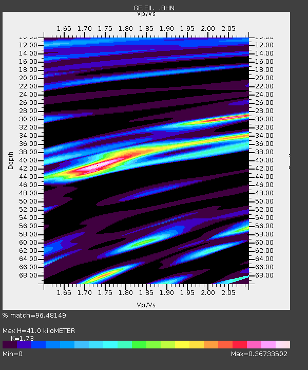
| Estimated Moho Depth: |
41.0 km |
| Estimated Crust Vp/Vs: |
1.73 |
| Assumed Crust Vp: |
6.472 km/s |
| Estimated Crust Vs: |
3.741 km/s |
| Estimated Crust Poisson's Ratio: |
0.25 |
|
| Radial Match: |
96.48149 % |
| Radial Bump: |
369 |
| Transverse Match: |
91.45833 % |
| Transverse Bump: |
400 |
| SOD ConfigId: |
4480 |
| Insert Time: |
2010-03-09 06:09:19.325 +0000 |
| GWidth: |
2.5 |
| Max Bumps: |
400 |
| Tol: |
0.001 |
|

Signal To Noise
| Channel | StoN | STA | LTA |
| GE:EIL: :BHN:19990308T12:37:48.477Z | 84.54695 | 5.1915517E-6 | 6.1404364E-8 |
| GE:EIL: :BHE:19990308T12:37:48.477Z | 25.567 | 1.5079952E-6 | 5.8982096E-8 |
| GE:EIL: :BHZ:19990308T12:37:48.477Z | 6.641072 | 6.7852017E-7 | 1.0217028E-7 |
| Arrivals |
| Ps | 4.7 SECOND |
| PpPs | 17 SECOND |
| PsPs/PpSs | 22 SECOND |


