You are here: Home > Network List > UU - University of Utah Regional Network Stations List
> Station HVU Hansel Valley, UT, USA > Earthquake Result Viewer
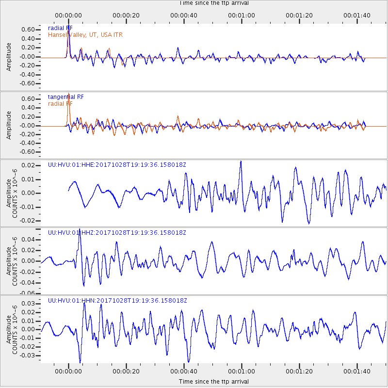
HVU Hansel Valley, UT, USA - Earthquake Result Viewer
*The percent match for this event was below the threshold and hence no stack was calculated.
| Earthquake location: |
North Of Franz Josef Land |
| Earthquake latitude/longitude: |
86.9/55.1 |
| Earthquake time(UTC): |
2017/10/28 (301) 19:11:01 GMT |
| Earthquake Depth: |
10 km |
| Earthquake Magnitude: |
6.0 Mww |
| Earthquake Catalog/Contributor: |
NEIC PDE/us |
|
| Network: |
UU University of Utah Regional Network |
| Station: |
HVU Hansel Valley, UT, USA |
| Lat/Lon: |
41.78 N/112.78 W |
| Elevation: |
1609 m |
|
| Distance: |
51.5 deg |
| Az: |
348.449 deg |
| Baz: |
0.837 deg |
| Ray Param: |
$rayparam |
*The percent match for this event was below the threshold and hence was not used in the summary stack. |
|
| Radial Match: |
77.26226 % |
| Radial Bump: |
388 |
| Transverse Match: |
71.148834 % |
| Transverse Bump: |
400 |
| SOD ConfigId: |
2364251 |
| Insert Time: |
2017-11-11 19:18:05.419 +0000 |
| GWidth: |
2.5 |
| Max Bumps: |
400 |
| Tol: |
0.001 |
|
Signal To Noise
| Channel | StoN | STA | LTA |
| UU:HVU:01:HHZ:20171028T19:19:36.158018Z | 2.7800694 | 2.1073369E-8 | 7.580159E-9 |
| UU:HVU:01:HHN:20171028T19:19:36.158018Z | 3.809167 | 1.3793824E-8 | 3.6212182E-9 |
| UU:HVU:01:HHE:20171028T19:19:36.158018Z | 0.6792033 | 3.2800385E-9 | 4.829244E-9 |
| Arrivals |
| Ps | |
| PpPs | |
| PsPs/PpSs | |


