You are here: Home > Network List > US - United States National Seismic Network Stations List
> Station WRAK Wrangell Island, Southeastern Alaska, Alaska, USA > Earthquake Result Viewer
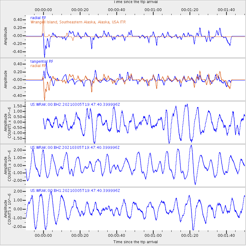
WRAK Wrangell Island, Southeastern Alaska, Alaska, USA - Earthquake Result Viewer
*The percent match for this event was below the threshold and hence no stack was calculated.
| Earthquake location: |
Kermadec Islands, New Zealand |
| Earthquake latitude/longitude: |
-30.3/-177.1 |
| Earthquake time(UTC): |
2021/03/05 (064) 19:34:52 GMT |
| Earthquake Depth: |
10 km |
| Earthquake Magnitude: |
5.5 mb |
| Earthquake Catalog/Contributor: |
NEIC PDE/us |
|
| Network: |
US United States National Seismic Network |
| Station: |
WRAK Wrangell Island, Southeastern Alaska, Alaska, USA |
| Lat/Lon: |
56.42 N/132.35 W |
| Elevation: |
81 m |
|
| Distance: |
94.4 deg |
| Az: |
23.084 deg |
| Baz: |
217.593 deg |
| Ray Param: |
$rayparam |
*The percent match for this event was below the threshold and hence was not used in the summary stack. |
|
| Radial Match: |
68.58734 % |
| Radial Bump: |
400 |
| Transverse Match: |
48.204624 % |
| Transverse Bump: |
400 |
| SOD ConfigId: |
23341671 |
| Insert Time: |
2021-03-19 20:47:46.551 +0000 |
| GWidth: |
2.5 |
| Max Bumps: |
400 |
| Tol: |
0.001 |
|
Signal To Noise
| Channel | StoN | STA | LTA |
| US:WRAK:00:BHZ:20210305T19:47:40.399996Z | 1.2674603 | 1.2549045E-6 | 9.900938E-7 |
| US:WRAK:00:BH1:20210305T19:47:40.399996Z | 2.3839638 | 1.4825939E-6 | 6.2190287E-7 |
| US:WRAK:00:BH2:20210305T19:47:40.399996Z | 0.92427796 | 4.7969996E-7 | 5.189997E-7 |
| Arrivals |
| Ps | |
| PpPs | |
| PsPs/PpSs | |


