You are here: Home > Network List > GE - GEOFON Stations List
> Station EIL GII/GEOFON Station Eilat, Israel > Earthquake Result Viewer
EIL GII/GEOFON Station Eilat, Israel - Earthquake Result Viewer
| Earthquake location: |
Mindanao, Philippines |
| Earthquake latitude/longitude: |
6.0/124.2 |
| Earthquake time(UTC): |
2002/03/05 (064) 21:16:09 GMT |
| Earthquake Depth: |
31 km |
| Earthquake Magnitude: |
6.3 MB, 7.2 MS, 7.5 MW, 7.2 MW |
| Earthquake Catalog/Contributor: |
WHDF/NEIC |
|
| Network: |
GE GEOFON |
| Station: |
EIL GII/GEOFON Station Eilat, Israel |
| Lat/Lon: |
29.67 N/34.95 E |
| Elevation: |
210 m |
|
| Distance: |
86.4 deg |
| Az: |
299.316 deg |
| Baz: |
85.122 deg |
| Ray Param: |
0.0440096 |
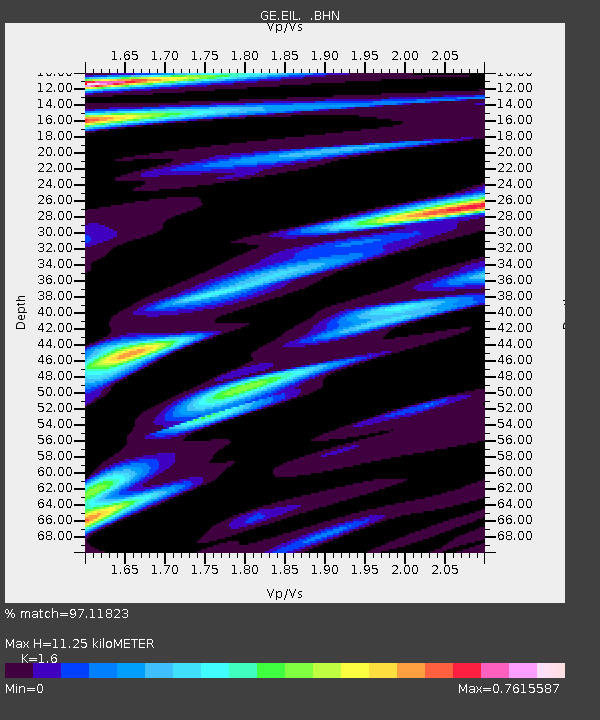
| Estimated Moho Depth: |
11.25 km |
| Estimated Crust Vp/Vs: |
1.60 |
| Assumed Crust Vp: |
6.472 km/s |
| Estimated Crust Vs: |
4.045 km/s |
| Estimated Crust Poisson's Ratio: |
0.18 |
|
| Radial Match: |
97.11823 % |
| Radial Bump: |
400 |
| Transverse Match: |
88.99197 % |
| Transverse Bump: |
400 |
| SOD ConfigId: |
20082 |
| Insert Time: |
2010-03-09 06:10:33.835 +0000 |
| GWidth: |
2.5 |
| Max Bumps: |
400 |
| Tol: |
0.001 |
|

Signal To Noise
| Channel | StoN | STA | LTA |
| GE:EIL: :BHN:20020305T21:28:17.385005Z | 1.0616578 | 5.3498095E-8 | 5.0391094E-8 |
| GE:EIL: :BHE:20020305T21:28:17.385005Z | 2.8816302 | 2.1008482E-7 | 7.2904854E-8 |
| GE:EIL: :BHZ:20020305T21:28:17.385005Z | 12.713231 | 9.559236E-7 | 7.5191245E-8 |
| Arrivals |
| Ps | 1.1 SECOND |
| PpPs | 4.4 SECOND |
| PsPs/PpSs | 5.5 SECOND |


