You are here: Home > Network List > GE - GEOFON Stations List
> Station EIL GII/GEOFON Station Eilat, Israel > Earthquake Result Viewer
EIL GII/GEOFON Station Eilat, Israel - Earthquake Result Viewer
| Earthquake location: |
Hokkaido, Japan Region |
| Earthquake latitude/longitude: |
41.2/142.2 |
| Earthquake time(UTC): |
2002/10/14 (287) 14:12:43 GMT |
| Earthquake Depth: |
61 km |
| Earthquake Magnitude: |
5.9 MB, 6.1 MW, 6.1 MW |
| Earthquake Catalog/Contributor: |
WHDF/NEIC |
|
| Network: |
GE GEOFON |
| Station: |
EIL GII/GEOFON Station Eilat, Israel |
| Lat/Lon: |
29.67 N/34.95 E |
| Elevation: |
210 m |
|
| Distance: |
82.7 deg |
| Az: |
303.091 deg |
| Baz: |
46.611 deg |
| Ray Param: |
0.046613105 |
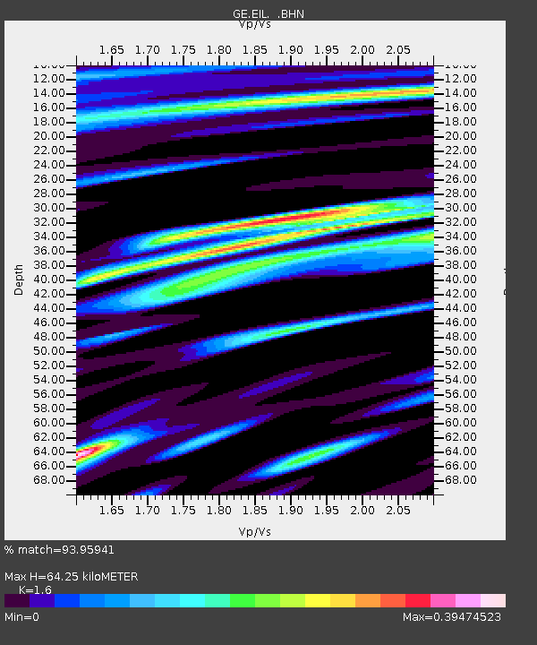
| Estimated Moho Depth: |
64.25 km |
| Estimated Crust Vp/Vs: |
1.60 |
| Assumed Crust Vp: |
6.472 km/s |
| Estimated Crust Vs: |
4.045 km/s |
| Estimated Crust Poisson's Ratio: |
0.18 |
|
| Radial Match: |
93.95941 % |
| Radial Bump: |
400 |
| Transverse Match: |
89.02424 % |
| Transverse Bump: |
400 |
| SOD ConfigId: |
4714 |
| Insert Time: |
2010-03-09 06:10:51.904 +0000 |
| GWidth: |
2.5 |
| Max Bumps: |
400 |
| Tol: |
0.001 |
|

Signal To Noise
| Channel | StoN | STA | LTA |
| GE:EIL: :BHN:20021014T14:24:29.513Z | 8.01493 | 4.1682264E-7 | 5.2005774E-8 |
| GE:EIL: :BHE:20021014T14:24:29.513Z | 7.9720783 | 4.4290178E-7 | 5.5556622E-8 |
| GE:EIL: :BHZ:20021014T14:24:29.513Z | 33.524746 | 1.8046386E-6 | 5.3830046E-8 |
| Arrivals |
| Ps | 6.1 SECOND |
| PpPs | 25 SECOND |
| PsPs/PpSs | 31 SECOND |


