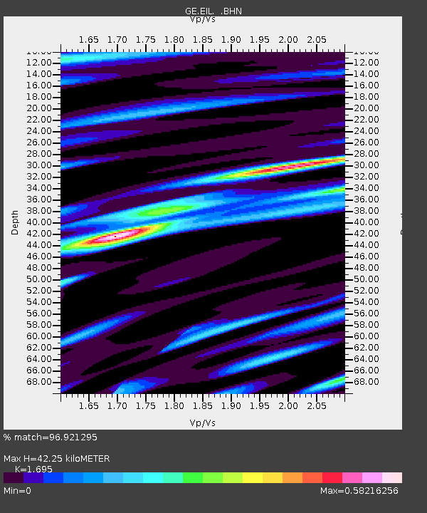
EIL GII/GEOFON Station Eilat, Israel - Earthquake Result Viewer

Earthquake location: Near East Coast Of Kamchatka
Earthquake latitude/longitude: 54.8/162.0
Earthquake time(UTC): 1997/12/05 (339) 11:26:54 GMT
Earthquake Depth: 33 km
Earthquake Magnitude: 6.3 MB, 7.6 MS, 7.9 UNKNOWN, 7.3 ME
Earthquake Catalog/Contributor: WHDF/NEIC
Network: GE GEOFON
Station: EIL GII/GEOFON Station Eilat, Israel
Lat/Lon: 29.67 N/34.95 E
Elevation: 210 m
Distance: 84.4 deg
Az: 315.76 deg
Baz: 27.625 deg
Ray Param: 0.04549159
Estimated Moho Depth: 42.25 km
Estimated Crust Vp/Vs: 1.70
Assumed Crust Vp: 6.472 km/s
Estimated Crust Vs: 3.818 km/s
Estimated Crust Poisson's Ratio: 0.23
Radial Match: 96.921295 %
Radial Bump: 400
Transverse Match: 91.75223 %
Transverse Bump: 400
SOD ConfigId: 4480
Insert Time: 2010-03-09 06:11:03.235 +0000
GWidth: 2.5
Max Bumps: 400
Tol: 0.001

Signal To Noise

ChannelStoNSTALTA
GE:EIL: :BHN:19971205T11:38:52.277002Z16.4339794.075409E-62.4798675E-7
GE:EIL: :BHE:19971205T11:38:52.277002Z9.1378061.2196234E-61.3347005E-7
GE:EIL: :BHZ:19971205T11:38:52.277002Z7.30959846.1478477E-78.41065E-8
Arrivals
Ps4.7 SECOND
PpPs17 SECOND
PsPs/PpSs22 SECOND