You are here: Home > Network List > WY - Yellowstone Wyoming Seismic Network Stations List
> Station YMP Mirror Lake Plateau, YNP, WY, USA > Earthquake Result Viewer
YMP Mirror Lake Plateau, YNP, WY, USA - Earthquake Result Viewer
| Earthquake location: |
North Of Franz Josef Land |
| Earthquake latitude/longitude: |
86.9/55.1 |
| Earthquake time(UTC): |
2017/10/28 (301) 19:11:01 GMT |
| Earthquake Depth: |
10 km |
| Earthquake Magnitude: |
6.0 Mww |
| Earthquake Catalog/Contributor: |
NEIC PDE/us |
|
| Network: |
WY Yellowstone Wyoming Seismic Network |
| Station: |
YMP Mirror Lake Plateau, YNP, WY, USA |
| Lat/Lon: |
44.74 N/110.16 W |
| Elevation: |
2774 m |
|
| Distance: |
48.5 deg |
| Az: |
346.015 deg |
| Baz: |
1.06 deg |
| Ray Param: |
0.069332555 |
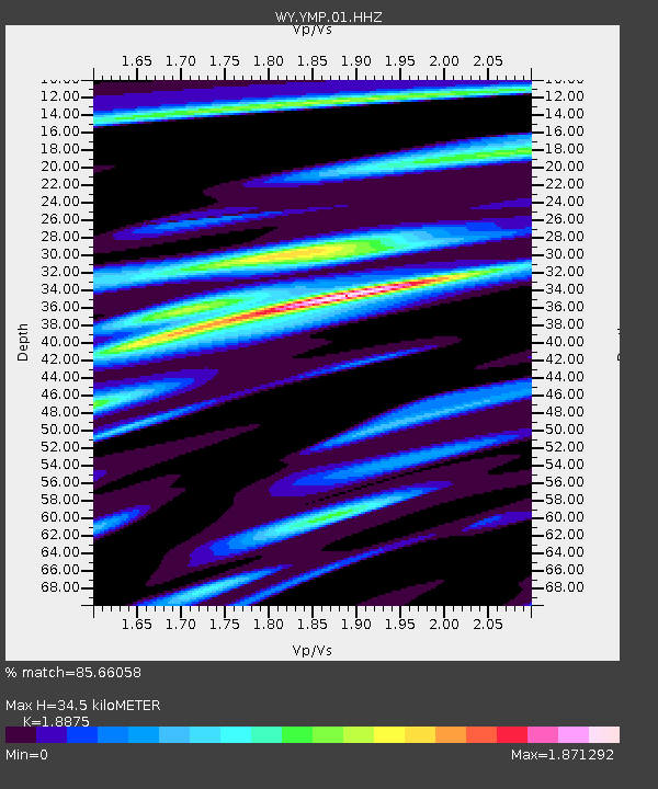
| Estimated Moho Depth: |
34.5 km |
| Estimated Crust Vp/Vs: |
1.89 |
| Assumed Crust Vp: |
6.35 km/s |
| Estimated Crust Vs: |
3.364 km/s |
| Estimated Crust Poisson's Ratio: |
0.30 |
|
| Radial Match: |
85.66058 % |
| Radial Bump: |
400 |
| Transverse Match: |
80.81019 % |
| Transverse Bump: |
384 |
| SOD ConfigId: |
2364251 |
| Insert Time: |
2017-11-11 19:18:54.129 +0000 |
| GWidth: |
2.5 |
| Max Bumps: |
400 |
| Tol: |
0.001 |
|

Signal To Noise
| Channel | StoN | STA | LTA |
| WY:YMP:01:HHZ:20171028T19:19:13.468015Z | 6.6238256 | 2.9990016E-8 | 4.5275974E-9 |
| WY:YMP:01:HHN:20171028T19:19:13.468015Z | 1.3284626 | 1.6590784E-8 | 1.248871E-8 |
| WY:YMP:01:HHE:20171028T19:19:13.468015Z | 0.5135219 | 3.8004004E-9 | 7.4006588E-9 |
| Arrivals |
| Ps | 5.1 SECOND |
| PpPs | 15 SECOND |
| PsPs/PpSs | 20 SECOND |


