You are here: Home > Network List > GE - GEOFON Stations List
> Station EIL GII/GEOFON Station Eilat, Israel > Earthquake Result Viewer
EIL GII/GEOFON Station Eilat, Israel - Earthquake Result Viewer
| Earthquake location: |
Southeast Of Taiwan |
| Earthquake latitude/longitude: |
22.3/125.3 |
| Earthquake time(UTC): |
1998/05/03 (123) 23:30:21 GMT |
| Earthquake Depth: |
33 km |
| Earthquake Magnitude: |
6.4 MB, 7.3 MS, 7.5 UNKNOWN, 7.5 ME |
| Earthquake Catalog/Contributor: |
WHDF/NEIC |
|
| Network: |
GE GEOFON |
| Station: |
EIL GII/GEOFON Station Eilat, Israel |
| Lat/Lon: |
29.67 N/34.95 E |
| Elevation: |
210 m |
|
| Distance: |
79.6 deg |
| Az: |
297.762 deg |
| Baz: |
70.316 deg |
| Ray Param: |
0.048817087 |
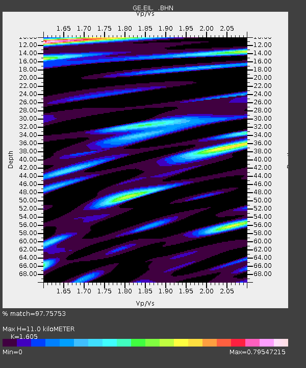
| Estimated Moho Depth: |
11.0 km |
| Estimated Crust Vp/Vs: |
1.61 |
| Assumed Crust Vp: |
6.472 km/s |
| Estimated Crust Vs: |
4.032 km/s |
| Estimated Crust Poisson's Ratio: |
0.18 |
|
| Radial Match: |
97.75753 % |
| Radial Bump: |
400 |
| Transverse Match: |
91.52102 % |
| Transverse Bump: |
400 |
| SOD ConfigId: |
4480 |
| Insert Time: |
2010-03-09 06:12:18.852 +0000 |
| GWidth: |
2.5 |
| Max Bumps: |
400 |
| Tol: |
0.001 |
|

Signal To Noise
| Channel | StoN | STA | LTA |
| GE:EIL: :BHN:19980503T23:41:54.553015Z | 4.478569 | 3.2124345E-7 | 7.172904E-8 |
| GE:EIL: :BHE:19980503T23:41:54.553015Z | 1.2505437 | 4.975886E-8 | 3.9789782E-8 |
| GE:EIL: :BHZ:19980503T23:41:54.553015Z | 1.8733381 | 9.585853E-8 | 5.1169906E-8 |
| Arrivals |
| Ps | 1.1 SECOND |
| PpPs | 4.3 SECOND |
| PsPs/PpSs | 5.3 SECOND |


