You are here: Home > Network List > US - United States National Seismic Network Stations List
> Station HAWA Hanford, Washington, USA > Earthquake Result Viewer
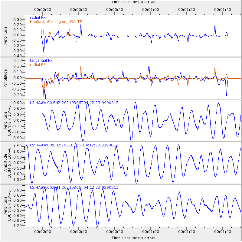
HAWA Hanford, Washington, USA - Earthquake Result Viewer
*The percent match for this event was below the threshold and hence no stack was calculated.
| Earthquake location: |
Kermadec Islands Region |
| Earthquake latitude/longitude: |
-29.9/-176.9 |
| Earthquake time(UTC): |
2021/03/06 (065) 03:59:46 GMT |
| Earthquake Depth: |
10 km |
| Earthquake Magnitude: |
5.5 mww |
| Earthquake Catalog/Contributor: |
NEIC PDE/us |
|
| Network: |
US United States National Seismic Network |
| Station: |
HAWA Hanford, Washington, USA |
| Lat/Lon: |
46.39 N/119.53 W |
| Elevation: |
364 m |
|
| Distance: |
91.9 deg |
| Az: |
35.656 deg |
| Baz: |
226.976 deg |
| Ray Param: |
$rayparam |
*The percent match for this event was below the threshold and hence was not used in the summary stack. |
|
| Radial Match: |
44.71397 % |
| Radial Bump: |
282 |
| Transverse Match: |
57.563747 % |
| Transverse Bump: |
397 |
| SOD ConfigId: |
23341671 |
| Insert Time: |
2021-03-20 05:15:04.591 +0000 |
| GWidth: |
2.5 |
| Max Bumps: |
400 |
| Tol: |
0.001 |
|
Signal To Noise
| Channel | StoN | STA | LTA |
| US:HAWA:00:BHZ:20210306T04:12:23.999001Z | 1.1318092 | 7.6636877E-7 | 6.771183E-7 |
| US:HAWA:00:BH1:20210306T04:12:23.999001Z | 5.2036896 | 8.1047193E-7 | 1.5574948E-7 |
| US:HAWA:00:BH2:20210306T04:12:23.999001Z | 0.7831067 | 3.6356047E-7 | 4.642541E-7 |
| Arrivals |
| Ps | |
| PpPs | |
| PsPs/PpSs | |


