You are here: Home > Network List > IU - Global Seismograph Network (GSN - IRIS/USGS) Stations List
> Station PMG Port Moresby, New Guinea > Earthquake Result Viewer
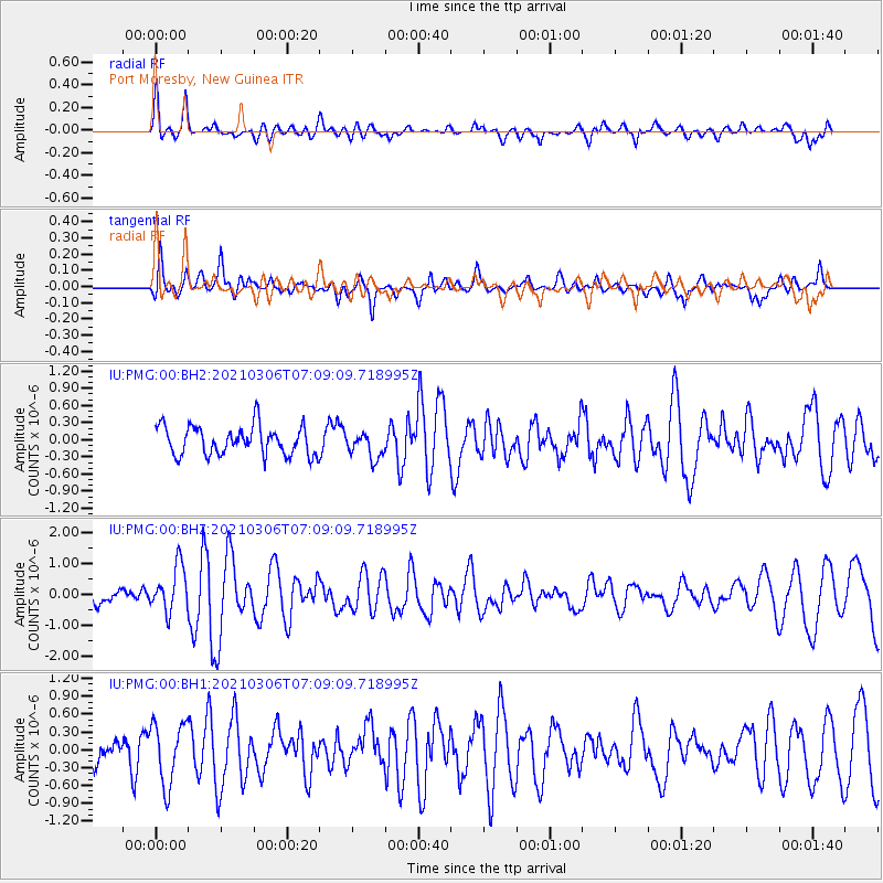
PMG Port Moresby, New Guinea - Earthquake Result Viewer
*The percent match for this event was below the threshold and hence no stack was calculated.
| Earthquake location: |
Kermadec Islands Region |
| Earthquake latitude/longitude: |
-28.5/-178.0 |
| Earthquake time(UTC): |
2021/03/06 (065) 07:02:24 GMT |
| Earthquake Depth: |
10 km |
| Earthquake Magnitude: |
5.8 mww |
| Earthquake Catalog/Contributor: |
NEIC PDE/us |
|
| Network: |
IU Global Seismograph Network (GSN - IRIS/USGS) |
| Station: |
PMG Port Moresby, New Guinea |
| Lat/Lon: |
9.40 S/147.16 E |
| Elevation: |
90 m |
|
| Distance: |
37.8 deg |
| Az: |
293.212 deg |
| Baz: |
124.925 deg |
| Ray Param: |
$rayparam |
*The percent match for this event was below the threshold and hence was not used in the summary stack. |
|
| Radial Match: |
71.590675 % |
| Radial Bump: |
400 |
| Transverse Match: |
69.675156 % |
| Transverse Bump: |
400 |
| SOD ConfigId: |
23341671 |
| Insert Time: |
2021-03-20 08:11:34.989 +0000 |
| GWidth: |
2.5 |
| Max Bumps: |
400 |
| Tol: |
0.001 |
|
Signal To Noise
| Channel | StoN | STA | LTA |
| IU:PMG:00:BHZ:20210306T07:09:09.718995Z | 2.6545978 | 7.3856586E-7 | 2.7822136E-7 |
| IU:PMG:00:BH1:20210306T07:09:09.718995Z | 1.8636397 | 5.151495E-7 | 2.764212E-7 |
| IU:PMG:00:BH2:20210306T07:09:09.718995Z | 0.90599954 | 2.2681517E-7 | 2.50348E-7 |
| Arrivals |
| Ps | |
| PpPs | |
| PsPs/PpSs | |


