You are here: Home > Network List > IU - Global Seismograph Network (GSN - IRIS/USGS) Stations List
> Station MBWA Marble Bar, Western Australia > Earthquake Result Viewer
MBWA Marble Bar, Western Australia - Earthquake Result Viewer
| Earthquake location: |
Kermadec Islands Region |
| Earthquake latitude/longitude: |
-28.4/-177.7 |
| Earthquake time(UTC): |
2021/03/06 (065) 10:34:47 GMT |
| Earthquake Depth: |
10 km |
| Earthquake Magnitude: |
5.7 mb |
| Earthquake Catalog/Contributor: |
NEIC PDE/us |
|
| Network: |
IU Global Seismograph Network (GSN - IRIS/USGS) |
| Station: |
MBWA Marble Bar, Western Australia |
| Lat/Lon: |
21.16 S/119.73 E |
| Elevation: |
190 m |
|
| Distance: |
56.7 deg |
| Az: |
262.242 deg |
| Baz: |
110.674 deg |
| Ray Param: |
0.0639754 |
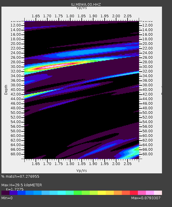
| Estimated Moho Depth: |
29.5 km |
| Estimated Crust Vp/Vs: |
1.73 |
| Assumed Crust Vp: |
6.464 km/s |
| Estimated Crust Vs: |
3.742 km/s |
| Estimated Crust Poisson's Ratio: |
0.25 |
|
| Radial Match: |
87.276955 % |
| Radial Bump: |
283 |
| Transverse Match: |
67.735855 % |
| Transverse Bump: |
400 |
| SOD ConfigId: |
23341671 |
| Insert Time: |
2021-03-20 11:43:48.930 +0000 |
| GWidth: |
2.5 |
| Max Bumps: |
400 |
| Tol: |
0.001 |
|

Signal To Noise
| Channel | StoN | STA | LTA |
| IU:MBWA:00:HHZ:20210306T10:44:00.177982Z | 2.7021863 | 7.9600267E-7 | 2.9457726E-7 |
| IU:MBWA:00:HH1:20210306T10:44:00.177982Z | 2.2448318 | 3.841995E-7 | 1.7114847E-7 |
| IU:MBWA:00:HH2:20210306T10:44:00.177982Z | 0.87349176 | 1.07425485E-7 | 1.2298396E-7 |
| Arrivals |
| Ps | 3.5 SECOND |
| PpPs | 12 SECOND |
| PsPs/PpSs | 15 SECOND |


