You are here: Home > Network List > US - United States National Seismic Network Stations List
> Station AMTX Amarillo, Texas, USA > Earthquake Result Viewer
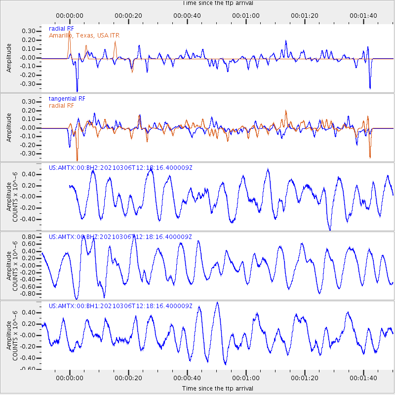
AMTX Amarillo, Texas, USA - Earthquake Result Viewer
*The percent match for this event was below the threshold and hence no stack was calculated.
| Earthquake location: |
Kermadec Islands Region |
| Earthquake latitude/longitude: |
-28.3/-177.9 |
| Earthquake time(UTC): |
2021/03/06 (065) 12:05:23 GMT |
| Earthquake Depth: |
10 km |
| Earthquake Magnitude: |
6.2 mww |
| Earthquake Catalog/Contributor: |
NEIC PDE/us |
|
| Network: |
US United States National Seismic Network |
| Station: |
AMTX Amarillo, Texas, USA |
| Lat/Lon: |
34.53 N/101.41 W |
| Elevation: |
1010 m |
|
| Distance: |
95.5 deg |
| Az: |
53.76 deg |
| Baz: |
239.448 deg |
| Ray Param: |
$rayparam |
*The percent match for this event was below the threshold and hence was not used in the summary stack. |
|
| Radial Match: |
75.23219 % |
| Radial Bump: |
400 |
| Transverse Match: |
46.18666 % |
| Transverse Bump: |
400 |
| SOD ConfigId: |
23341671 |
| Insert Time: |
2021-03-20 13:21:49.038 +0000 |
| GWidth: |
2.5 |
| Max Bumps: |
400 |
| Tol: |
0.001 |
|
Signal To Noise
| Channel | StoN | STA | LTA |
| US:AMTX:00:BHZ:20210306T12:18:16.400009Z | 3.1583266 | 6.0348975E-7 | 1.9107895E-7 |
| US:AMTX:00:BH1:20210306T12:18:16.400009Z | 0.676319 | 1.5807684E-7 | 2.3373117E-7 |
| US:AMTX:00:BH2:20210306T12:18:16.400009Z | 1.2261769 | 2.8526142E-7 | 2.3264295E-7 |
| Arrivals |
| Ps | |
| PpPs | |
| PsPs/PpSs | |


