You are here: Home > Network List > UU - University of Utah Regional Network Stations List
> Station CCUT Cedar City, UT, USA > Earthquake Result Viewer
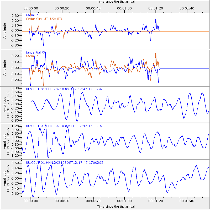
CCUT Cedar City, UT, USA - Earthquake Result Viewer
*The percent match for this event was below the threshold and hence no stack was calculated.
| Earthquake location: |
Kermadec Islands Region |
| Earthquake latitude/longitude: |
-28.3/-177.9 |
| Earthquake time(UTC): |
2021/03/06 (065) 12:05:23 GMT |
| Earthquake Depth: |
10 km |
| Earthquake Magnitude: |
6.2 mww |
| Earthquake Catalog/Contributor: |
NEIC PDE/us |
|
| Network: |
UU University of Utah Regional Network |
| Station: |
CCUT Cedar City, UT, USA |
| Lat/Lon: |
37.55 N/113.36 W |
| Elevation: |
2127 m |
|
| Distance: |
89.2 deg |
| Az: |
45.865 deg |
| Baz: |
232.751 deg |
| Ray Param: |
$rayparam |
*The percent match for this event was below the threshold and hence was not used in the summary stack. |
|
| Radial Match: |
81.03976 % |
| Radial Bump: |
400 |
| Transverse Match: |
68.34545 % |
| Transverse Bump: |
400 |
| SOD ConfigId: |
23341671 |
| Insert Time: |
2021-03-20 13:22:03.295 +0000 |
| GWidth: |
2.5 |
| Max Bumps: |
400 |
| Tol: |
0.001 |
|
Signal To Noise
| Channel | StoN | STA | LTA |
| UU:CCUT:01:HHZ:20210306T12:17:47.170029Z | 2.6452851 | 9.203773E-7 | 3.4793123E-7 |
| UU:CCUT:01:HHN:20210306T12:17:47.170029Z | 1.5817864 | 4.5611844E-7 | 2.8835655E-7 |
| UU:CCUT:01:HHE:20210306T12:17:47.170029Z | 1.8353351 | 5.33147E-7 | 2.9049028E-7 |
| Arrivals |
| Ps | |
| PpPs | |
| PsPs/PpSs | |


