You are here: Home > Network List > G - GEOSCOPE Stations List
> Station DRV Dumont d'Urville, Terre Adelie (Antartica) > Earthquake Result Viewer
DRV Dumont d'Urville, Terre Adelie (Antartica) - Earthquake Result Viewer
| Earthquake location: |
Southeast Of Loyalty Islands |
| Earthquake latitude/longitude: |
-21.7/169.2 |
| Earthquake time(UTC): |
2017/10/31 (304) 00:42:06 GMT |
| Earthquake Depth: |
9.1 km |
| Earthquake Magnitude: |
6.8 Mww |
| Earthquake Catalog/Contributor: |
NEIC PDE/us |
|
| Network: |
G GEOSCOPE |
| Station: |
DRV Dumont d'Urville, Terre Adelie (Antartica) |
| Lat/Lon: |
66.67 S/140.01 E |
| Elevation: |
40 m |
|
| Distance: |
48.7 deg |
| Az: |
194.994 deg |
| Baz: |
37.166 deg |
| Ray Param: |
0.0691955 |
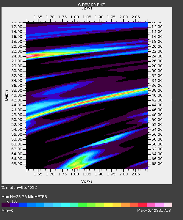
| Estimated Moho Depth: |
23.75 km |
| Estimated Crust Vp/Vs: |
1.60 |
| Assumed Crust Vp: |
6.39 km/s |
| Estimated Crust Vs: |
3.994 km/s |
| Estimated Crust Poisson's Ratio: |
0.18 |
|
| Radial Match: |
95.4022 % |
| Radial Bump: |
255 |
| Transverse Match: |
80.55971 % |
| Transverse Bump: |
400 |
| SOD ConfigId: |
2429771 |
| Insert Time: |
2017-11-14 00:42:42.974 +0000 |
| GWidth: |
2.5 |
| Max Bumps: |
400 |
| Tol: |
0.001 |
|
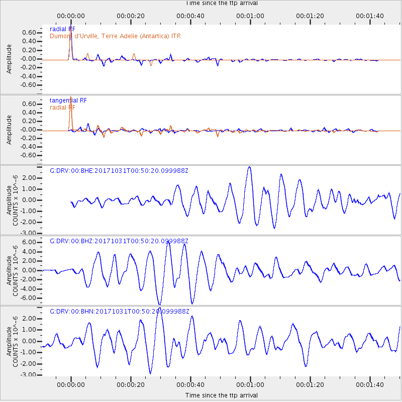
Signal To Noise
| Channel | StoN | STA | LTA |
| G:DRV:00:BHZ:20171031T00:50:20.099988Z | 2.199504 | 6.478012E-7 | 2.945215E-7 |
| G:DRV:00:BHN:20171031T00:50:20.099988Z | 1.3535131 | 3.0028306E-7 | 2.2185456E-7 |
| G:DRV:00:BHE:20171031T00:50:20.099988Z | 1.1815999 | 2.808688E-7 | 2.3770212E-7 |
| Arrivals |
| Ps | 2.4 SECOND |
| PpPs | 9.0 SECOND |
| PsPs/PpSs | 11 SECOND |


