You are here: Home > Network List > II - Global Seismograph Network (GSN - IRIS/IDA) Stations List
> Station PFO Pinon Flat, California, USA > Earthquake Result Viewer
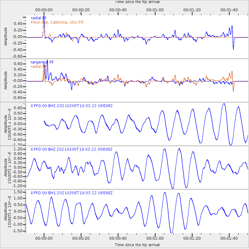
PFO Pinon Flat, California, USA - Earthquake Result Viewer
*The percent match for this event was below the threshold and hence no stack was calculated.
| Earthquake location: |
Mariana Islands |
| Earthquake latitude/longitude: |
20.9/144.3 |
| Earthquake time(UTC): |
2021/03/06 (065) 18:51:13 GMT |
| Earthquake Depth: |
10 km |
| Earthquake Magnitude: |
5.7 Mww |
| Earthquake Catalog/Contributor: |
NEIC PDE/us |
|
| Network: |
II Global Seismograph Network (GSN - IRIS/IDA) |
| Station: |
PFO Pinon Flat, California, USA |
| Lat/Lon: |
33.61 N/116.46 W |
| Elevation: |
1280 m |
|
| Distance: |
86.0 deg |
| Az: |
55.665 deg |
| Baz: |
292.295 deg |
| Ray Param: |
$rayparam |
*The percent match for this event was below the threshold and hence was not used in the summary stack. |
|
| Radial Match: |
40.011997 % |
| Radial Bump: |
400 |
| Transverse Match: |
79.00868 % |
| Transverse Bump: |
400 |
| SOD ConfigId: |
23341671 |
| Insert Time: |
2021-03-20 20:07:34.480 +0000 |
| GWidth: |
2.5 |
| Max Bumps: |
400 |
| Tol: |
0.001 |
|
Signal To Noise
| Channel | StoN | STA | LTA |
| II:PFO:00:BHZ:20210306T19:03:22.06898Z | 0.7412036 | 3.1015492E-7 | 4.1844768E-7 |
| II:PFO:00:BH1:20210306T19:03:22.06898Z | 1.5479122 | 7.8979394E-7 | 5.1023176E-7 |
| II:PFO:00:BH2:20210306T19:03:22.06898Z | 1.2842628 | 3.1471498E-7 | 2.4505496E-7 |
| Arrivals |
| Ps | |
| PpPs | |
| PsPs/PpSs | |


