You are here: Home > Network List > TA - USArray Transportable Network (new EarthScope stations) Stations List
> Station R31K City Hall, Gustavus, AK, USA > Earthquake Result Viewer
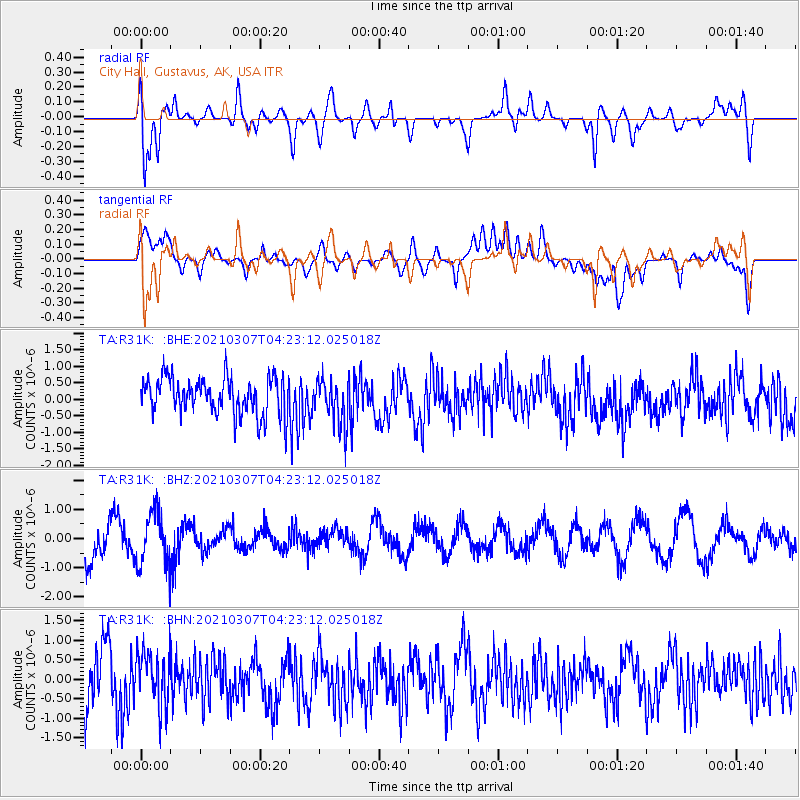
R31K City Hall, Gustavus, AK, USA - Earthquake Result Viewer
*The percent match for this event was below the threshold and hence no stack was calculated.
| Earthquake location: |
Kermadec Islands Region |
| Earthquake latitude/longitude: |
-29.2/-176.5 |
| Earthquake time(UTC): |
2021/03/07 (066) 04:10:26 GMT |
| Earthquake Depth: |
10 km |
| Earthquake Magnitude: |
5.5 mb |
| Earthquake Catalog/Contributor: |
NEIC PDE/us |
|
| Network: |
TA USArray Transportable Network (new EarthScope stations) |
| Station: |
R31K City Hall, Gustavus, AK, USA |
| Lat/Lon: |
58.41 N/135.74 W |
| Elevation: |
15 m |
|
| Distance: |
93.7 deg |
| Az: |
20.161 deg |
| Baz: |
214.918 deg |
| Ray Param: |
$rayparam |
*The percent match for this event was below the threshold and hence was not used in the summary stack. |
|
| Radial Match: |
62.409996 % |
| Radial Bump: |
400 |
| Transverse Match: |
38.20857 % |
| Transverse Bump: |
400 |
| SOD ConfigId: |
23341671 |
| Insert Time: |
2021-03-21 05:23:27.169 +0000 |
| GWidth: |
2.5 |
| Max Bumps: |
400 |
| Tol: |
0.001 |
|
Signal To Noise
| Channel | StoN | STA | LTA |
| TA:R31K: :BHZ:20210307T04:23:12.025018Z | 1.3975354 | 8.892713E-7 | 6.363139E-7 |
| TA:R31K: :BHN:20210307T04:23:12.025018Z | 1.1091634 | 7.13157E-7 | 6.429684E-7 |
| TA:R31K: :BHE:20210307T04:23:12.025018Z | 1.2358115 | 6.886531E-7 | 5.572477E-7 |
| Arrivals |
| Ps | |
| PpPs | |
| PsPs/PpSs | |


