You are here: Home > Network List > WY - Yellowstone Wyoming Seismic Network Stations List
> Station YEE East Entrance, YNP, WY, USA > Earthquake Result Viewer
YEE East Entrance, YNP, WY, USA - Earthquake Result Viewer
| Earthquake location: |
Kermadec Islands Region |
| Earthquake latitude/longitude: |
-28.5/-177.0 |
| Earthquake time(UTC): |
2021/03/07 (066) 19:28:47 GMT |
| Earthquake Depth: |
10 km |
| Earthquake Magnitude: |
5.5 mb |
| Earthquake Catalog/Contributor: |
NEIC PDE/us |
|
| Network: |
WY Yellowstone Wyoming Seismic Network |
| Station: |
YEE East Entrance, YNP, WY, USA |
| Lat/Lon: |
44.49 N/109.90 W |
| Elevation: |
2270 m |
|
| Distance: |
95.0 deg |
| Az: |
41.449 deg |
| Baz: |
234.453 deg |
| Ray Param: |
0.040907994 |
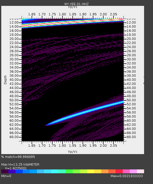
| Estimated Moho Depth: |
13.25 km |
| Estimated Crust Vp/Vs: |
1.62 |
| Assumed Crust Vp: |
6.242 km/s |
| Estimated Crust Vs: |
3.847 km/s |
| Estimated Crust Poisson's Ratio: |
0.19 |
|
| Radial Match: |
99.996895 % |
| Radial Bump: |
3 |
| Transverse Match: |
99.9504 % |
| Transverse Bump: |
8 |
| SOD ConfigId: |
23341671 |
| Insert Time: |
2021-03-21 20:43:29.062 +0000 |
| GWidth: |
2.5 |
| Max Bumps: |
400 |
| Tol: |
0.001 |
|

Signal To Noise
| Channel | StoN | STA | LTA |
| WY:YEE:01:HHZ:20210307T19:41:38.970022Z | 1.4669807 | 1.0169191E-6 | 6.9320555E-7 |
| WY:YEE:01:HHN:20210307T19:41:38.970022Z | 1.4793223 | 2.4906666E-7 | 1.6836536E-7 |
| WY:YEE:01:HHE:20210307T19:41:38.970022Z | 1.4631085 | 1.0069602E-6 | 6.8823346E-7 |
| Arrivals |
| Ps | 1.3 SECOND |
| PpPs | 5.5 SECOND |
| PsPs/PpSs | 6.8 SECOND |


