You are here: Home > Network List > WY - Yellowstone Wyoming Seismic Network Stations List
> Station YHH Holmes Hill, YNP, WY, USA > Earthquake Result Viewer
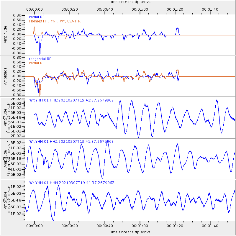
YHH Holmes Hill, YNP, WY, USA - Earthquake Result Viewer
*The percent match for this event was below the threshold and hence no stack was calculated.
| Earthquake location: |
Kermadec Islands Region |
| Earthquake latitude/longitude: |
-28.5/-177.0 |
| Earthquake time(UTC): |
2021/03/07 (066) 19:28:47 GMT |
| Earthquake Depth: |
10 km |
| Earthquake Magnitude: |
5.5 mb |
| Earthquake Catalog/Contributor: |
NEIC PDE/us |
|
| Network: |
WY Yellowstone Wyoming Seismic Network |
| Station: |
YHH Holmes Hill, YNP, WY, USA |
| Lat/Lon: |
44.79 N/110.85 W |
| Elevation: |
2717 m |
|
| Distance: |
94.6 deg |
| Az: |
40.803 deg |
| Baz: |
233.84 deg |
| Ray Param: |
$rayparam |
*The percent match for this event was below the threshold and hence was not used in the summary stack. |
|
| Radial Match: |
77.593254 % |
| Radial Bump: |
375 |
| Transverse Match: |
71.172195 % |
| Transverse Bump: |
400 |
| SOD ConfigId: |
23341671 |
| Insert Time: |
2021-03-21 20:43:32.678 +0000 |
| GWidth: |
2.5 |
| Max Bumps: |
400 |
| Tol: |
0.001 |
|
Signal To Noise
| Channel | StoN | STA | LTA |
| WY:YHH:01:HHZ:20210307T19:41:37.267996Z | 1.9799858 | 7.580403E-9 | 3.8285135E-9 |
| WY:YHH:01:HHN:20210307T19:41:37.267996Z | 1.1278669 | 5.5519207E-9 | 4.9224966E-9 |
| WY:YHH:01:HHE:20210307T19:41:37.267996Z | 1.3752912 | 6.8379045E-9 | 4.9719686E-9 |
| Arrivals |
| Ps | |
| PpPs | |
| PsPs/PpSs | |


