You are here: Home > Network List > IW - Intermountain West Stations List
> Station PLID Pearl Lake, Idaho, USA > Earthquake Result Viewer
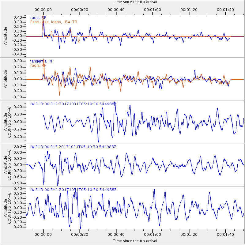
PLID Pearl Lake, Idaho, USA - Earthquake Result Viewer
*The percent match for this event was below the threshold and hence no stack was calculated.
| Earthquake location: |
Tonga Islands |
| Earthquake latitude/longitude: |
-15.5/-173.3 |
| Earthquake time(UTC): |
2017/10/31 (304) 04:58:58 GMT |
| Earthquake Depth: |
35 km |
| Earthquake Magnitude: |
5.8 mb |
| Earthquake Catalog/Contributor: |
NEIC PDE/us |
|
| Network: |
IW Intermountain West |
| Station: |
PLID Pearl Lake, Idaho, USA |
| Lat/Lon: |
45.09 N/116.00 W |
| Elevation: |
2164 m |
|
| Distance: |
79.6 deg |
| Az: |
37.32 deg |
| Baz: |
235.585 deg |
| Ray Param: |
$rayparam |
*The percent match for this event was below the threshold and hence was not used in the summary stack. |
|
| Radial Match: |
70.08535 % |
| Radial Bump: |
400 |
| Transverse Match: |
54.442425 % |
| Transverse Bump: |
400 |
| SOD ConfigId: |
2429771 |
| Insert Time: |
2017-11-14 05:01:17.063 +0000 |
| GWidth: |
2.5 |
| Max Bumps: |
400 |
| Tol: |
0.001 |
|
Signal To Noise
| Channel | StoN | STA | LTA |
| IW:PLID:00:BHZ:20171031T05:10:30.544988Z | 2.84832 | 4.256307E-7 | 1.4943218E-7 |
| IW:PLID:00:BH1:20171031T05:10:30.544988Z | 1.4185789 | 1.4591737E-7 | 1.02861655E-7 |
| IW:PLID:00:BH2:20171031T05:10:30.544988Z | 2.127846 | 2.3278317E-7 | 1.0939849E-7 |
| Arrivals |
| Ps | |
| PpPs | |
| PsPs/PpSs | |


