You are here: Home > Network List > AZ - ANZA Regional Network Stations List
> Station SMER AZ.SMER > Earthquake Result Viewer
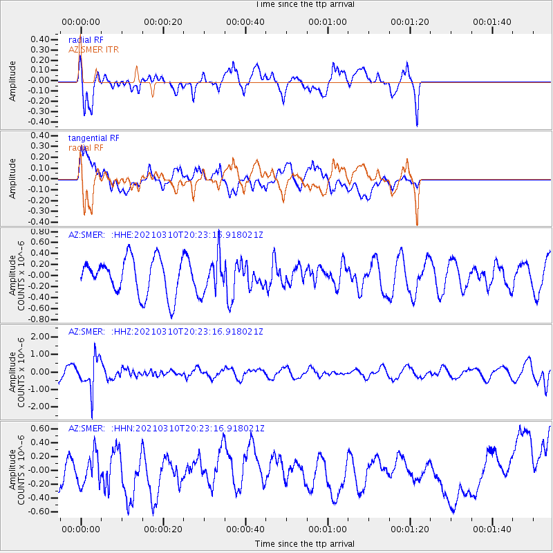
SMER AZ.SMER - Earthquake Result Viewer
*The percent match for this event was below the threshold and hence no stack was calculated.
| Earthquake location: |
Fiji Islands Region |
| Earthquake latitude/longitude: |
-20.1/-177.7 |
| Earthquake time(UTC): |
2021/03/10 (069) 20:12:37 GMT |
| Earthquake Depth: |
488 km |
| Earthquake Magnitude: |
5.8 Mww |
| Earthquake Catalog/Contributor: |
NEIC PDE/us |
|
| Network: |
AZ ANZA Regional Network |
| Station: |
SMER AZ.SMER |
| Lat/Lon: |
33.46 N/117.17 W |
| Elevation: |
355 m |
|
| Distance: |
78.5 deg |
| Az: |
47.943 deg |
| Baz: |
236.568 deg |
| Ray Param: |
$rayparam |
*The percent match for this event was below the threshold and hence was not used in the summary stack. |
|
| Radial Match: |
74.279045 % |
| Radial Bump: |
400 |
| Transverse Match: |
30.617054 % |
| Transverse Bump: |
400 |
| SOD ConfigId: |
24334971 |
| Insert Time: |
2021-03-24 20:23:08.829 +0000 |
| GWidth: |
2.5 |
| Max Bumps: |
400 |
| Tol: |
0.001 |
|
Signal To Noise
| Channel | StoN | STA | LTA |
| AZ:SMER: :HHZ:20210310T20:23:16.918021Z | 2.7701943 | 9.1903667E-7 | 3.3175894E-7 |
| AZ:SMER: :HHN:20210310T20:23:16.918021Z | 0.6973629 | 2.5094963E-7 | 3.5985514E-7 |
| AZ:SMER: :HHE:20210310T20:23:16.918021Z | 0.992202 | 3.266786E-7 | 3.2924606E-7 |
| Arrivals |
| Ps | |
| PpPs | |
| PsPs/PpSs | |


