You are here: Home > Network List > G - GEOSCOPE Stations List
> Station INU Inuyama, Japan > Earthquake Result Viewer
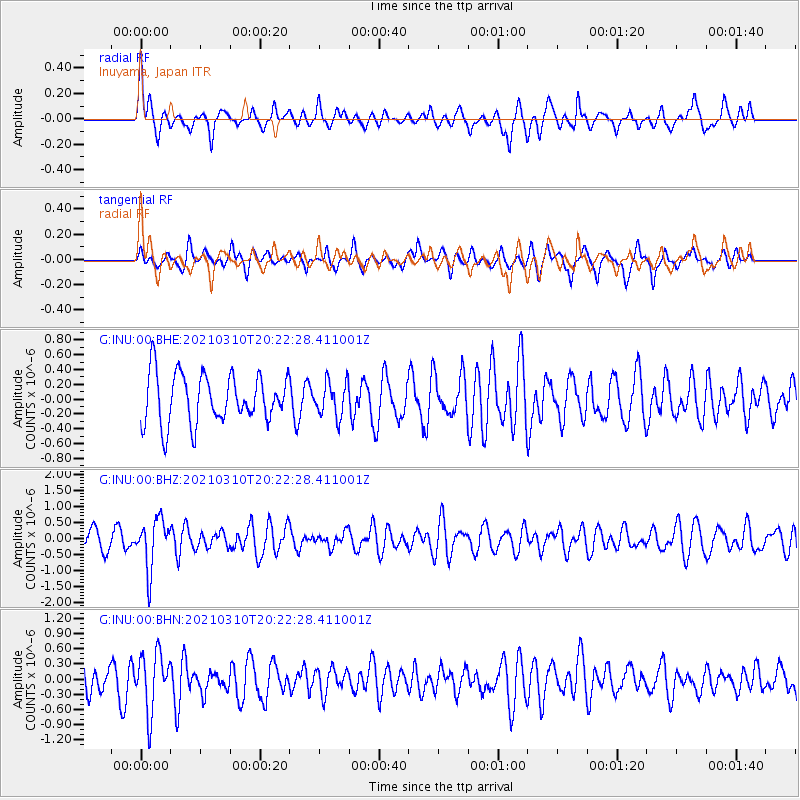
INU Inuyama, Japan - Earthquake Result Viewer
*The percent match for this event was below the threshold and hence no stack was calculated.
| Earthquake location: |
Fiji Islands Region |
| Earthquake latitude/longitude: |
-20.1/-177.7 |
| Earthquake time(UTC): |
2021/03/10 (069) 20:12:37 GMT |
| Earthquake Depth: |
488 km |
| Earthquake Magnitude: |
5.8 Mww |
| Earthquake Catalog/Contributor: |
NEIC PDE/us |
|
| Network: |
G GEOSCOPE |
| Station: |
INU Inuyama, Japan |
| Lat/Lon: |
35.35 N/137.03 E |
| Elevation: |
132 m |
|
| Distance: |
69.9 deg |
| Az: |
321.786 deg |
| Baz: |
134.679 deg |
| Ray Param: |
$rayparam |
*The percent match for this event was below the threshold and hence was not used in the summary stack. |
|
| Radial Match: |
65.93153 % |
| Radial Bump: |
374 |
| Transverse Match: |
65.67581 % |
| Transverse Bump: |
393 |
| SOD ConfigId: |
24334971 |
| Insert Time: |
2021-03-24 20:28:50.678 +0000 |
| GWidth: |
2.5 |
| Max Bumps: |
400 |
| Tol: |
0.001 |
|
Signal To Noise
| Channel | StoN | STA | LTA |
| G:INU:00:BHZ:20210310T20:22:28.411001Z | 3.087502 | 7.7411073E-7 | 2.5072396E-7 |
| G:INU:00:BHN:20210310T20:22:28.411001Z | 1.695307 | 5.7163766E-7 | 3.3718828E-7 |
| G:INU:00:BHE:20210310T20:22:28.411001Z | 0.70747495 | 2.3423576E-7 | 3.31087E-7 |
| Arrivals |
| Ps | |
| PpPs | |
| PsPs/PpSs | |


