You are here: Home > Network List > US - United States National Seismic Network Stations List
> Station BOZ Bozeman, Montana, USA > Earthquake Result Viewer
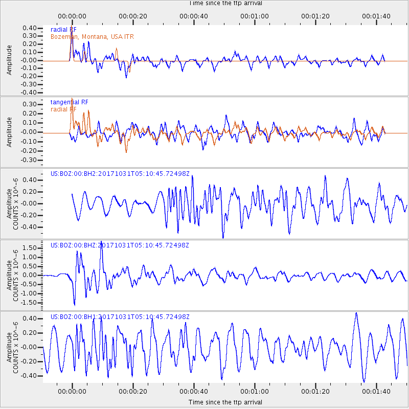
BOZ Bozeman, Montana, USA - Earthquake Result Viewer
*The percent match for this event was below the threshold and hence no stack was calculated.
| Earthquake location: |
Tonga Islands |
| Earthquake latitude/longitude: |
-15.5/-173.3 |
| Earthquake time(UTC): |
2017/10/31 (304) 04:58:58 GMT |
| Earthquake Depth: |
35 km |
| Earthquake Magnitude: |
5.8 mb |
| Earthquake Catalog/Contributor: |
NEIC PDE/us |
|
| Network: |
US United States National Seismic Network |
| Station: |
BOZ Bozeman, Montana, USA |
| Lat/Lon: |
45.65 N/111.63 W |
| Elevation: |
1589 m |
|
| Distance: |
82.5 deg |
| Az: |
38.532 deg |
| Baz: |
238.875 deg |
| Ray Param: |
$rayparam |
*The percent match for this event was below the threshold and hence was not used in the summary stack. |
|
| Radial Match: |
66.248405 % |
| Radial Bump: |
400 |
| Transverse Match: |
64.365456 % |
| Transverse Bump: |
400 |
| SOD ConfigId: |
2429771 |
| Insert Time: |
2017-11-14 05:03:03.258 +0000 |
| GWidth: |
2.5 |
| Max Bumps: |
400 |
| Tol: |
0.001 |
|
Signal To Noise
| Channel | StoN | STA | LTA |
| US:BOZ:00:BHZ:20171031T05:10:45.72498Z | 6.260034 | 8.1805797E-7 | 1.3067947E-7 |
| US:BOZ:00:BH1:20171031T05:10:45.72498Z | 1.1477562 | 2.0260745E-7 | 1.7652481E-7 |
| US:BOZ:00:BH2:20171031T05:10:45.72498Z | 2.0288076 | 2.1981451E-7 | 1.0834665E-7 |
| Arrivals |
| Ps | |
| PpPs | |
| PsPs/PpSs | |


