You are here: Home > Network List > XW97 - Tien Shan Continental Dynamics Stations List
> Station KAR XW.KAR > Earthquake Result Viewer
KAR XW.KAR - Earthquake Result Viewer
| Earthquake location: |
Hokkaido, Japan Region |
| Earthquake latitude/longitude: |
43.8/145.0 |
| Earthquake time(UTC): |
1997/11/15 (319) 07:05:16 GMT |
| Earthquake Depth: |
161 km |
| Earthquake Magnitude: |
5.8 MB, 6.1 UNKNOWN, 6.1 MW |
| Earthquake Catalog/Contributor: |
WHDF/NEIC |
|
| Network: |
XW Tien Shan Continental Dynamics |
| Station: |
KAR XW.KAR |
| Lat/Lon: |
42.47 N/78.40 E |
| Elevation: |
1778 m |
|
| Distance: |
47.4 deg |
| Az: |
292.73 deg |
| Baz: |
64.487 deg |
| Ray Param: |
0.06943731 |
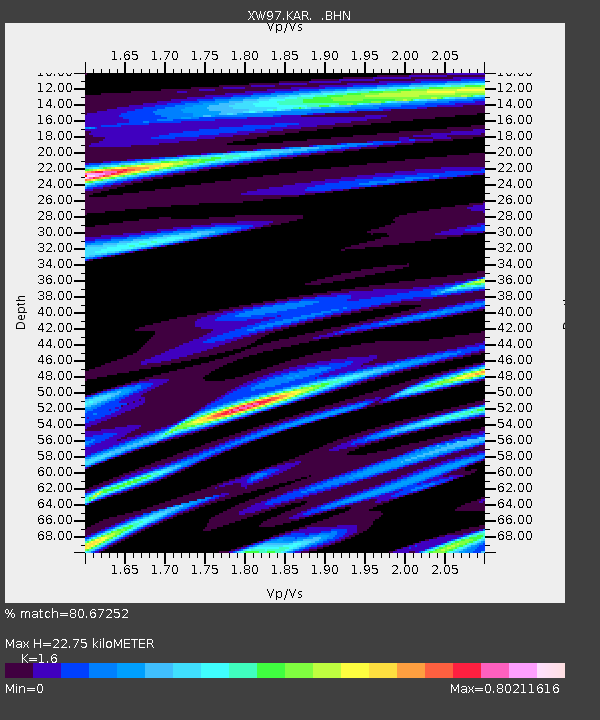
| Estimated Moho Depth: |
22.75 km |
| Estimated Crust Vp/Vs: |
1.60 |
| Assumed Crust Vp: |
6.306 km/s |
| Estimated Crust Vs: |
3.941 km/s |
| Estimated Crust Poisson's Ratio: |
0.18 |
|
| Radial Match: |
80.67252 % |
| Radial Bump: |
400 |
| Transverse Match: |
84.30811 % |
| Transverse Bump: |
400 |
| SOD ConfigId: |
4480 |
| Insert Time: |
2010-02-26 15:24:57.718 +0000 |
| GWidth: |
2.5 |
| Max Bumps: |
400 |
| Tol: |
0.001 |
|
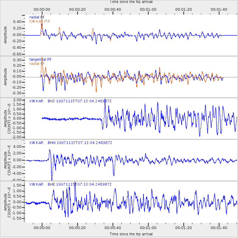
Signal To Noise
| Channel | StoN | STA | LTA |
| XW:KAR: :BHN:19971115T07:13:04.248987Z | 21.26848 | 1.1233334E-6 | 5.2816816E-8 |
| XW:KAR: :BHE:19971115T07:13:04.248987Z | 3.8128762 | 1.8027167E-7 | 4.727971E-8 |
| XW:KAR: :BHZ:19971115T07:13:04.248987Z | 5.8090568 | 3.6718538E-7 | 6.320912E-8 |
| Arrivals |
| Ps | 2.3 SECOND |
| PpPs | 8.8 SECOND |
| PsPs/PpSs | 11 SECOND |


