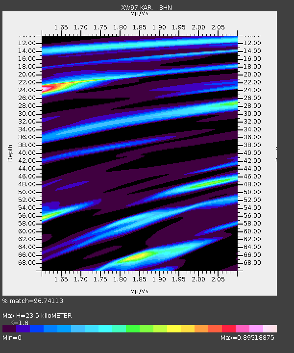
KAR XW.KAR - Earthquake Result Viewer
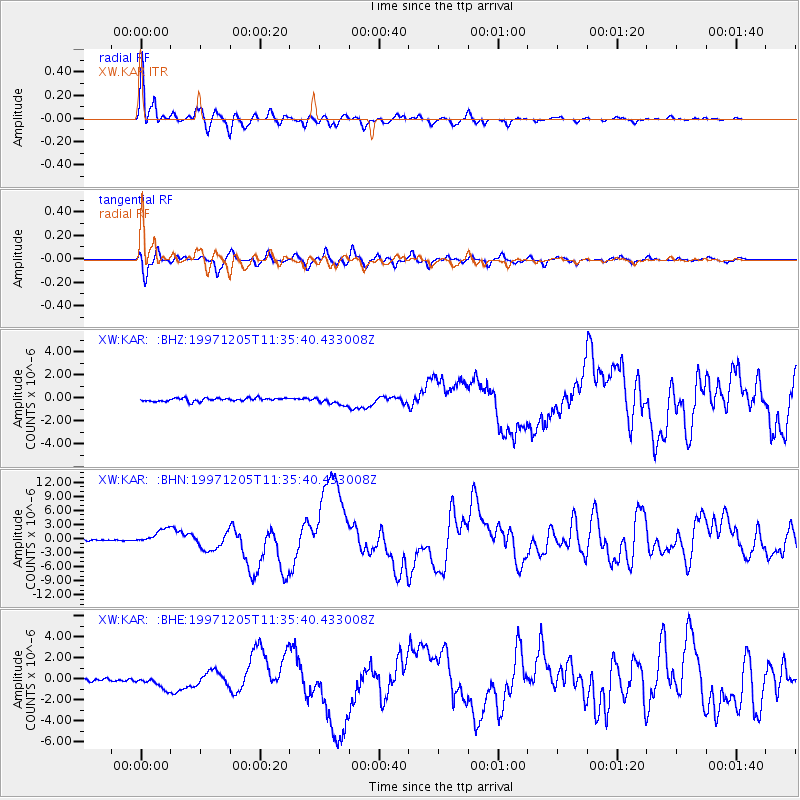
Earthquake location: Near East Coast Of Kamchatka
Earthquake latitude/longitude: 54.8/162.0
Earthquake time(UTC): 1997/12/05 (339) 11:26:54 GMT
Earthquake Depth: 33 km
Earthquake Magnitude: 6.3 MB, 7.6 MS, 7.9 UNKNOWN, 7.3 ME
Earthquake Catalog/Contributor: WHDF/NEIC
Network: XW Tien Shan Continental Dynamics
Station: KAR XW.KAR
Lat/Lon: 42.47 N/78.40 E
Elevation: 1778 m
Distance: 53.4 deg
Az: 293.666 deg
Baz: 45.732 deg
Ray Param: 0.06606394
Estimated Moho Depth: 23.5 km
Estimated Crust Vp/Vs: 1.60
Assumed Crust Vp: 6.306 km/s
Estimated Crust Vs: 3.941 km/s
Estimated Crust Poisson's Ratio: 0.18
Radial Match: 96.74113 %
Radial Bump: 382
Transverse Match: 90.955635 %
Transverse Bump: 400
SOD ConfigId: 4480
Insert Time: 2010-02-26 15:25:00.197 +0000
GWidth: 2.5
Max Bumps: 400
Tol: 0.001

Signal To Noise

ChannelStoNSTALTA
XW:KAR: :BHN:19971205T11:35:40.433008Z14.930431.5907359E-61.06543204E-7
XW:KAR: :BHE:19971205T11:35:40.433008Z6.0610935.6285063E-79.286289E-8
XW:KAR: :BHZ:19971205T11:35:40.433008Z2.47980143.4305802E-71.3834094E-7
Arrivals
Ps2.4 SECOND
PpPs9.1 SECOND
PsPs/PpSs12 SECOND