You are here: Home > Network List > TA - USArray Transportable Network (new EarthScope stations) Stations List
> Station I17K Unalakleet, AK, USA > Earthquake Result Viewer
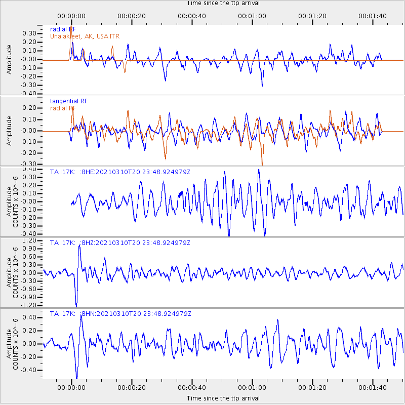
I17K Unalakleet, AK, USA - Earthquake Result Viewer
*The percent match for this event was below the threshold and hence no stack was calculated.
| Earthquake location: |
Fiji Islands Region |
| Earthquake latitude/longitude: |
-20.1/-177.7 |
| Earthquake time(UTC): |
2021/03/10 (069) 20:12:37 GMT |
| Earthquake Depth: |
488 km |
| Earthquake Magnitude: |
5.8 Mww |
| Earthquake Catalog/Contributor: |
NEIC PDE/us |
|
| Network: |
TA USArray Transportable Network (new EarthScope stations) |
| Station: |
I17K Unalakleet, AK, USA |
| Lat/Lon: |
63.89 N/160.70 W |
| Elevation: |
105 m |
|
| Distance: |
84.8 deg |
| Az: |
7.456 deg |
| Baz: |
195.993 deg |
| Ray Param: |
$rayparam |
*The percent match for this event was below the threshold and hence was not used in the summary stack. |
|
| Radial Match: |
56.48049 % |
| Radial Bump: |
392 |
| Transverse Match: |
47.590046 % |
| Transverse Bump: |
399 |
| SOD ConfigId: |
24334971 |
| Insert Time: |
2021-03-24 20:36:38.547 +0000 |
| GWidth: |
2.5 |
| Max Bumps: |
400 |
| Tol: |
0.001 |
|
Signal To Noise
| Channel | StoN | STA | LTA |
| TA:I17K: :BHZ:20210310T20:23:48.924979Z | 5.9657354 | 5.3137205E-7 | 8.907067E-8 |
| TA:I17K: :BHN:20210310T20:23:48.924979Z | 2.1771045 | 2.5336806E-7 | 1.1637845E-7 |
| TA:I17K: :BHE:20210310T20:23:48.924979Z | 1.2638474 | 1.17313924E-7 | 9.282286E-8 |
| Arrivals |
| Ps | |
| PpPs | |
| PsPs/PpSs | |


