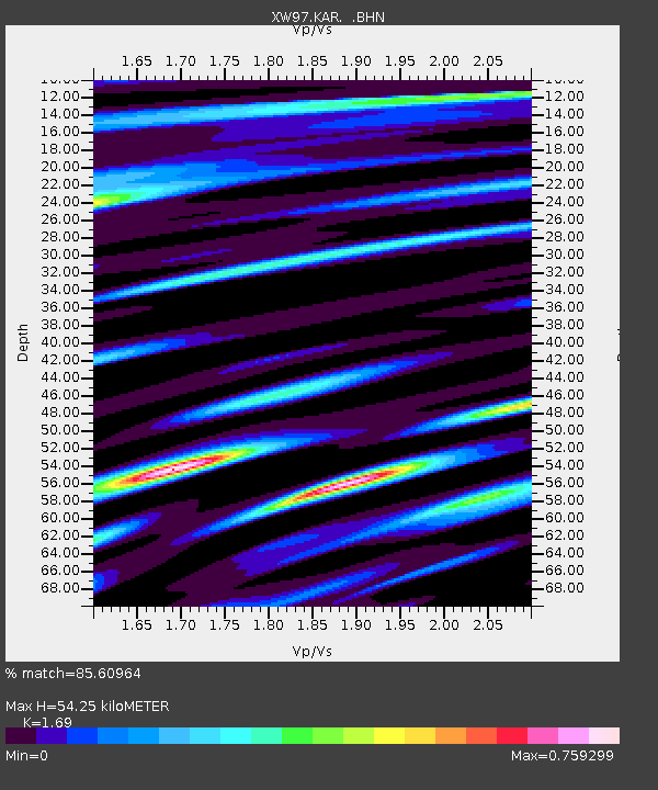
KAR XW.KAR - Earthquake Result Viewer
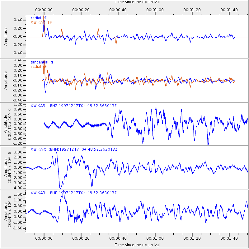
Earthquake location: Rat Islands, Aleutian Islands
Earthquake latitude/longitude: 51.2/178.9
Earthquake time(UTC): 1997/12/17 (351) 04:38:51 GMT
Earthquake Depth: 20 km
Earthquake Magnitude: 5.8 MB, 6.5 MS, 6.7 UNKNOWN, 6.1 ME
Earthquake Catalog/Contributor: WHDF/NEIC
Network: XW Tien Shan Continental Dynamics
Station: KAR XW.KAR
Lat/Lon: 42.47 N/78.40 E
Elevation: 1778 m
Distance: 64.0 deg
Az: 305.965 deg
Baz: 43.51 deg
Ray Param: 0.059180066
Estimated Moho Depth: 54.25 km
Estimated Crust Vp/Vs: 1.69
Assumed Crust Vp: 6.306 km/s
Estimated Crust Vs: 3.731 km/s
Estimated Crust Poisson's Ratio: 0.23
Radial Match: 85.60964 %
Radial Bump: 400
Transverse Match: 84.602264 %
Transverse Bump: 400
SOD ConfigId: 4480
Insert Time: 2010-02-26 15:25:06.854 +0000
GWidth: 2.5
Max Bumps: 400
Tol: 0.001

Signal To Noise

ChannelStoNSTALTA
XW:KAR: :BHN:19971217T04:48:52.363013Z7.1609987.055661E-79.8529014E-8
XW:KAR: :BHE:19971217T04:48:52.363013Z1.81904881.6351956E-78.989289E-8
XW:KAR: :BHZ:19971217T04:48:52.363013Z0.99412661.2606164E-71.2680641E-7
Arrivals
Ps6.2 SECOND
PpPs22 SECOND
PsPs/PpSs28 SECOND