You are here: Home > Network List > US - United States National Seismic Network Stations List
> Station WRAK Wrangell Island, Southeastern Alaska, Alaska, USA > Earthquake Result Viewer
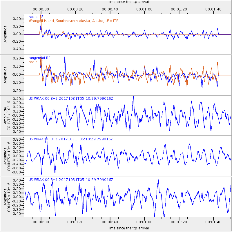
WRAK Wrangell Island, Southeastern Alaska, Alaska, USA - Earthquake Result Viewer
*The percent match for this event was below the threshold and hence no stack was calculated.
| Earthquake location: |
Tonga Islands |
| Earthquake latitude/longitude: |
-15.5/-173.3 |
| Earthquake time(UTC): |
2017/10/31 (304) 04:58:58 GMT |
| Earthquake Depth: |
35 km |
| Earthquake Magnitude: |
5.8 mb |
| Earthquake Catalog/Contributor: |
NEIC PDE/us |
|
| Network: |
US United States National Seismic Network |
| Station: |
WRAK Wrangell Island, Southeastern Alaska, Alaska, USA |
| Lat/Lon: |
56.42 N/132.35 W |
| Elevation: |
81 m |
|
| Distance: |
79.4 deg |
| Az: |
21.756 deg |
| Baz: |
220.013 deg |
| Ray Param: |
$rayparam |
*The percent match for this event was below the threshold and hence was not used in the summary stack. |
|
| Radial Match: |
54.272377 % |
| Radial Bump: |
400 |
| Transverse Match: |
51.503197 % |
| Transverse Bump: |
400 |
| SOD ConfigId: |
2429771 |
| Insert Time: |
2017-11-14 05:03:46.575 +0000 |
| GWidth: |
2.5 |
| Max Bumps: |
400 |
| Tol: |
0.001 |
|
Signal To Noise
| Channel | StoN | STA | LTA |
| US:WRAK:00:BHZ:20171031T05:10:29.799016Z | 2.4948316 | 4.854082E-7 | 1.9456552E-7 |
| US:WRAK:00:BH1:20171031T05:10:29.799016Z | 2.537849 | 2.2303776E-7 | 8.7884565E-8 |
| US:WRAK:00:BH2:20171031T05:10:29.799016Z | 1.3014706 | 1.8725396E-7 | 1.4387875E-7 |
| Arrivals |
| Ps | |
| PpPs | |
| PsPs/PpSs | |


