You are here: Home > Network List > US - United States National Seismic Network Stations List
> Station HLID Hailey, Idaho, USA > Earthquake Result Viewer
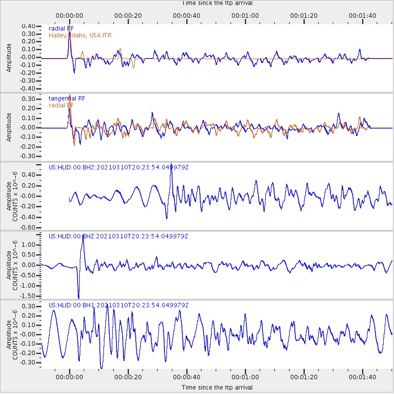
HLID Hailey, Idaho, USA - Earthquake Result Viewer
*The percent match for this event was below the threshold and hence no stack was calculated.
| Earthquake location: |
Fiji Islands Region |
| Earthquake latitude/longitude: |
-20.1/-177.7 |
| Earthquake time(UTC): |
2021/03/10 (069) 20:12:37 GMT |
| Earthquake Depth: |
488 km |
| Earthquake Magnitude: |
5.8 Mww |
| Earthquake Catalog/Contributor: |
NEIC PDE/us |
|
| Network: |
US United States National Seismic Network |
| Station: |
HLID Hailey, Idaho, USA |
| Lat/Lon: |
43.56 N/114.41 W |
| Elevation: |
1772 m |
|
| Distance: |
85.9 deg |
| Az: |
40.609 deg |
| Baz: |
237.284 deg |
| Ray Param: |
$rayparam |
*The percent match for this event was below the threshold and hence was not used in the summary stack. |
|
| Radial Match: |
62.306496 % |
| Radial Bump: |
358 |
| Transverse Match: |
47.33324 % |
| Transverse Bump: |
400 |
| SOD ConfigId: |
24334971 |
| Insert Time: |
2021-03-24 20:40:17.020 +0000 |
| GWidth: |
2.5 |
| Max Bumps: |
400 |
| Tol: |
0.001 |
|
Signal To Noise
| Channel | StoN | STA | LTA |
| US:HLID:00:BHZ:20210310T20:23:54.049979Z | 7.682475 | 6.816355E-7 | 8.872603E-8 |
| US:HLID:00:BH1:20210310T20:23:54.049979Z | 1.1198179 | 1.2068077E-7 | 1.077682E-7 |
| US:HLID:00:BH2:20210310T20:23:54.049979Z | 3.0935977 | 2.3594588E-7 | 7.626909E-8 |
| Arrivals |
| Ps | |
| PpPs | |
| PsPs/PpSs | |


