You are here: Home > Network List > WY - Yellowstone Wyoming Seismic Network Stations List
> Station YEE East Entrance, YNP, WY, USA > Earthquake Result Viewer
YEE East Entrance, YNP, WY, USA - Earthquake Result Viewer
| Earthquake location: |
Fiji Islands Region |
| Earthquake latitude/longitude: |
-20.1/-177.7 |
| Earthquake time(UTC): |
2021/03/10 (069) 20:12:37 GMT |
| Earthquake Depth: |
488 km |
| Earthquake Magnitude: |
5.8 Mww |
| Earthquake Catalog/Contributor: |
NEIC PDE/us |
|
| Network: |
WY Yellowstone Wyoming Seismic Network |
| Station: |
YEE East Entrance, YNP, WY, USA |
| Lat/Lon: |
44.49 N/109.90 W |
| Elevation: |
2270 m |
|
| Distance: |
89.1 deg |
| Az: |
41.505 deg |
| Baz: |
240.452 deg |
| Ray Param: |
0.04166679 |
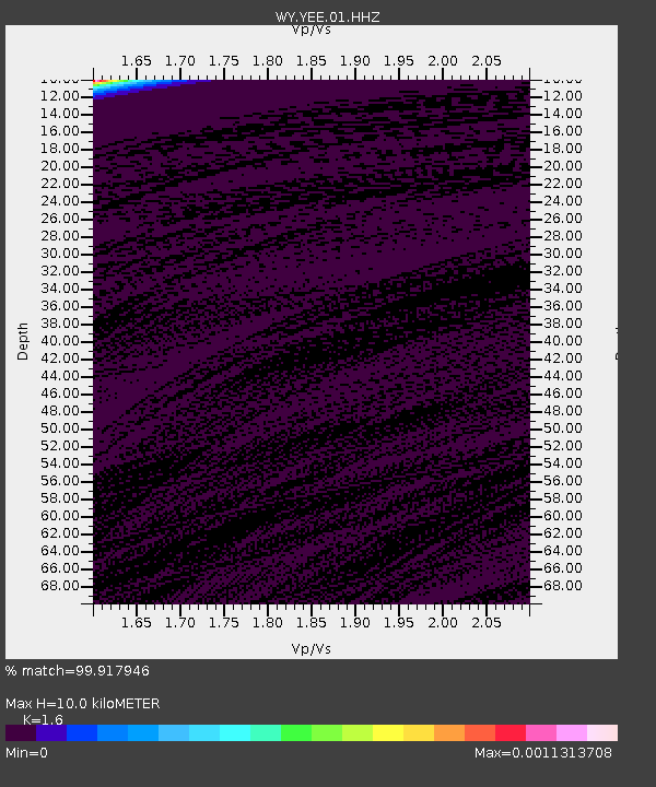
| Estimated Moho Depth: |
10.0 km |
| Estimated Crust Vp/Vs: |
1.60 |
| Assumed Crust Vp: |
6.242 km/s |
| Estimated Crust Vs: |
3.901 km/s |
| Estimated Crust Poisson's Ratio: |
0.18 |
|
| Radial Match: |
99.917946 % |
| Radial Bump: |
3 |
| Transverse Match: |
97.895584 % |
| Transverse Bump: |
114 |
| SOD ConfigId: |
24334971 |
| Insert Time: |
2021-03-24 20:43:14.385 +0000 |
| GWidth: |
2.5 |
| Max Bumps: |
400 |
| Tol: |
0.001 |
|

Signal To Noise
| Channel | StoN | STA | LTA |
| WY:YEE:01:HHZ:20210310T20:24:09.330008Z | 2.2569017 | 2.086971E-7 | 9.247062E-8 |
| WY:YEE:01:HHN:20210310T20:24:09.330008Z | 2.18537 | 5.3146135E-8 | 2.4319057E-8 |
| WY:YEE:01:HHE:20210310T20:24:09.330008Z | 2.2617779 | 2.0447635E-7 | 9.0405145E-8 |
| Arrivals |
| Ps | 1.0 SECOND |
| PpPs | 4.1 SECOND |
| PsPs/PpSs | 5.1 SECOND |


