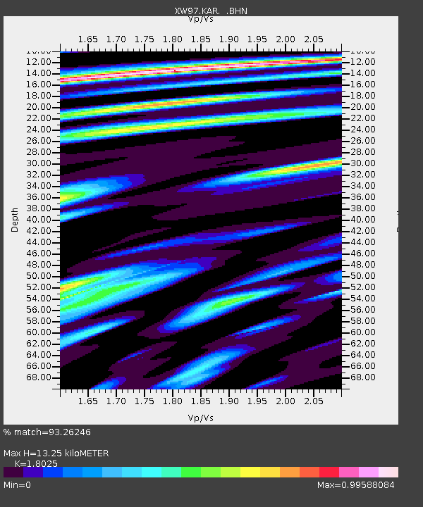
KAR XW.KAR - Earthquake Result Viewer
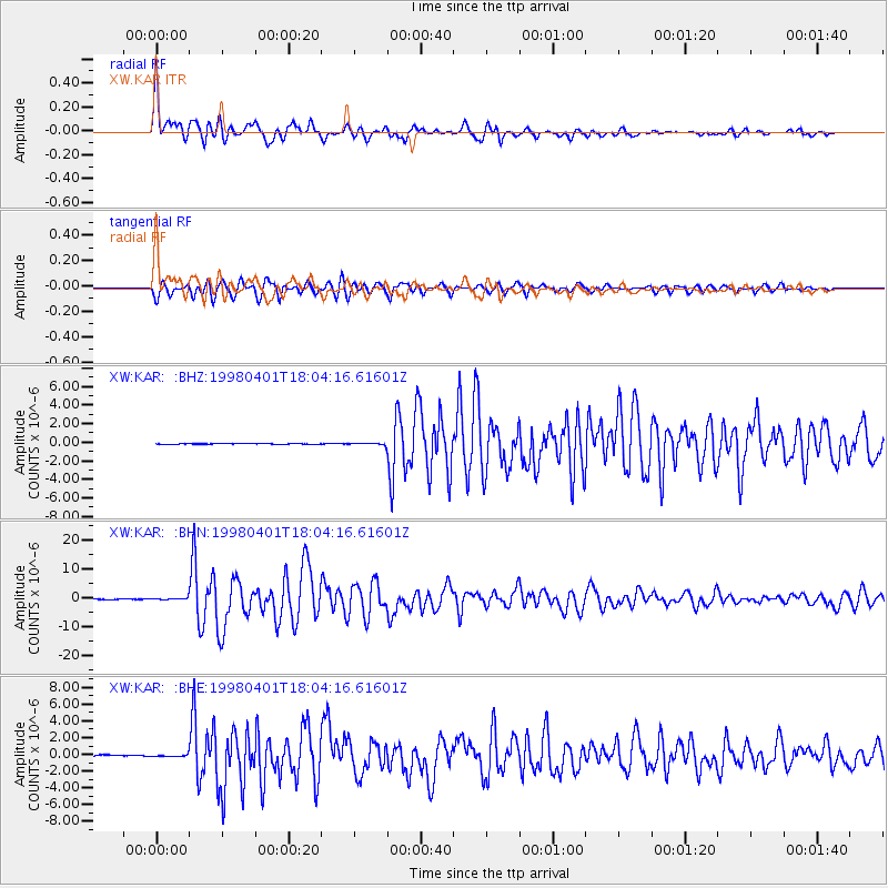
Earthquake location: Southern Sumatra, Indonesia
Earthquake latitude/longitude: -0.5/99.3
Earthquake time(UTC): 1998/04/01 (091) 17:56:23 GMT
Earthquake Depth: 56 km
Earthquake Magnitude: 6.2 MB, 6.9 MS, 7.0 UNKNOWN, 6.6 ME
Earthquake Catalog/Contributor: WHDF/NEIC
Network: XW Tien Shan Continental Dynamics
Station: KAR XW.KAR
Lat/Lon: 42.47 N/78.40 E
Elevation: 1778 m
Distance: 46.8 deg
Az: 338.801 deg
Baz: 150.742 deg
Ray Param: 0.07027587
Estimated Moho Depth: 13.25 km
Estimated Crust Vp/Vs: 1.80
Assumed Crust Vp: 6.306 km/s
Estimated Crust Vs: 3.498 km/s
Estimated Crust Poisson's Ratio: 0.28
Radial Match: 93.26246 %
Radial Bump: 400
Transverse Match: 90.07154 %
Transverse Bump: 400
SOD ConfigId: 4480
Insert Time: 2010-02-26 15:25:09.475 +0000
GWidth: 2.5
Max Bumps: 400
Tol: 0.001

Signal To Noise

ChannelStoNSTALTA
XW:KAR: :BHN:19980401T18:04:16.61601Z5.59973343.5947033E-76.419419E-8
XW:KAR: :BHE:19980401T18:04:16.61601Z1.58050781.363495E-78.6269424E-8
XW:KAR: :BHZ:19980401T18:04:16.61601Z2.41945489.137808E-83.7768043E-8
Arrivals
Ps1.8 SECOND
PpPs5.6 SECOND
PsPs/PpSs7.3 SECOND