You are here: Home > Network List > AV - Alaska Volcano Observatory Stations List
> Station SPCR Ckakachatna River, Mount Spurr, Alaska > Earthquake Result Viewer
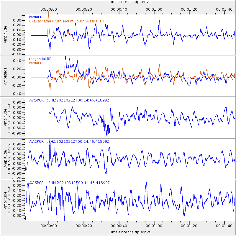
SPCR Ckakachatna River, Mount Spurr, Alaska - Earthquake Result Viewer
*The percent match for this event was below the threshold and hence no stack was calculated.
| Earthquake location: |
South Of Fiji Islands |
| Earthquake latitude/longitude: |
-25.2/178.4 |
| Earthquake time(UTC): |
2021/03/12 (071) 00:03:19 GMT |
| Earthquake Depth: |
541 km |
| Earthquake Magnitude: |
5.8 mww |
| Earthquake Catalog/Contributor: |
NEIC PDE/us |
|
| Network: |
AV Alaska Volcano Observatory |
| Station: |
SPCR Ckakachatna River, Mount Spurr, Alaska |
| Lat/Lon: |
61.20 N/152.21 W |
| Elevation: |
984 m |
|
| Distance: |
89.3 deg |
| Az: |
13.753 deg |
| Baz: |
206.419 deg |
| Ray Param: |
$rayparam |
*The percent match for this event was below the threshold and hence was not used in the summary stack. |
|
| Radial Match: |
50.930042 % |
| Radial Bump: |
400 |
| Transverse Match: |
36.35452 % |
| Transverse Bump: |
400 |
| SOD ConfigId: |
24334971 |
| Insert Time: |
2021-03-26 00:08:26.614 +0000 |
| GWidth: |
2.5 |
| Max Bumps: |
400 |
| Tol: |
0.001 |
|
Signal To Noise
| Channel | StoN | STA | LTA |
| AV:SPCR: :BHZ:20210312T00:14:46.41899Z | 1.7114391 | 4.2682146E-7 | 2.493933E-7 |
| AV:SPCR: :BHN:20210312T00:14:46.41899Z | 0.7872929 | 2.6660894E-7 | 3.3864006E-7 |
| AV:SPCR: :BHE:20210312T00:14:46.41899Z | 2.5342653 | 6.50155E-7 | 2.5654577E-7 |
| Arrivals |
| Ps | |
| PpPs | |
| PsPs/PpSs | |


