You are here: Home > Network List > AZ - ANZA Regional Network Stations List
> Station SMER AZ.SMER > Earthquake Result Viewer
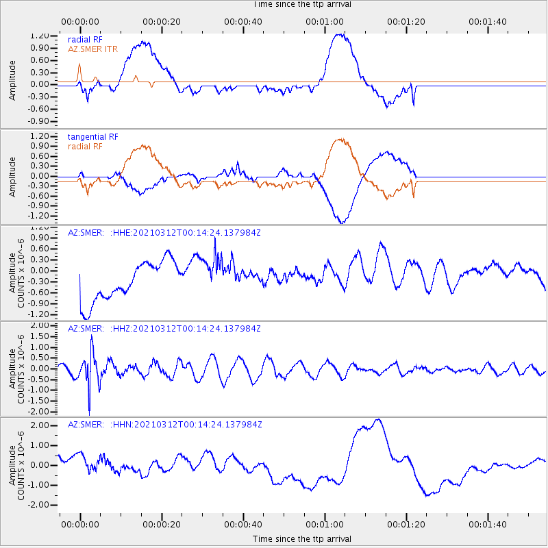
SMER AZ.SMER - Earthquake Result Viewer
*The percent match for this event was below the threshold and hence no stack was calculated.
| Earthquake location: |
South Of Fiji Islands |
| Earthquake latitude/longitude: |
-25.2/178.4 |
| Earthquake time(UTC): |
2021/03/12 (071) 00:03:19 GMT |
| Earthquake Depth: |
541 km |
| Earthquake Magnitude: |
5.8 mww |
| Earthquake Catalog/Contributor: |
NEIC PDE/us |
|
| Network: |
AZ ANZA Regional Network |
| Station: |
SMER AZ.SMER |
| Lat/Lon: |
33.46 N/117.17 W |
| Elevation: |
355 m |
|
| Distance: |
84.6 deg |
| Az: |
49.252 deg |
| Baz: |
235.211 deg |
| Ray Param: |
$rayparam |
*The percent match for this event was below the threshold and hence was not used in the summary stack. |
|
| Radial Match: |
30.481178 % |
| Radial Bump: |
400 |
| Transverse Match: |
27.207155 % |
| Transverse Bump: |
400 |
| SOD ConfigId: |
24334971 |
| Insert Time: |
2021-03-26 00:08:51.193 +0000 |
| GWidth: |
2.5 |
| Max Bumps: |
400 |
| Tol: |
0.001 |
|
Signal To Noise
| Channel | StoN | STA | LTA |
| AZ:SMER: :HHZ:20210312T00:14:24.137984Z | 5.57148 | 7.347351E-7 | 1.3187432E-7 |
| AZ:SMER: :HHN:20210312T00:14:24.137984Z | 0.8529416 | 8.810036E-7 | 1.0329003E-6 |
| AZ:SMER: :HHE:20210312T00:14:24.137984Z | 1.1239148 | 5.954257E-7 | 5.2977833E-7 |
| Arrivals |
| Ps | |
| PpPs | |
| PsPs/PpSs | |


