You are here: Home > Network List > CI - Caltech Regional Seismic Network Stations List
> Station TUQ Turquiose Mountain, Baker, CA, USA > Earthquake Result Viewer
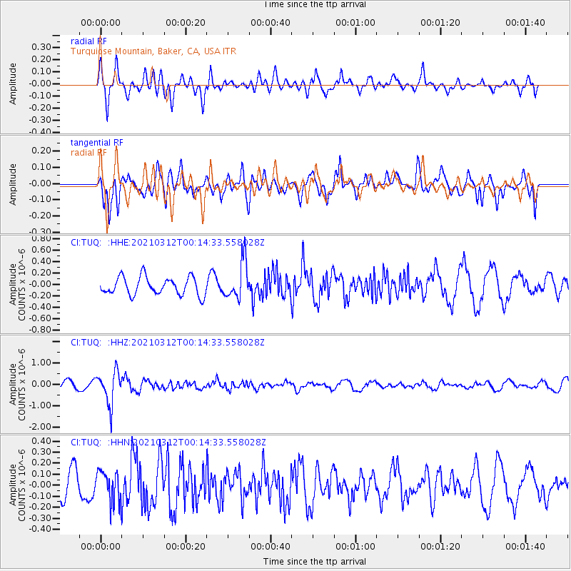
TUQ Turquiose Mountain, Baker, CA, USA - Earthquake Result Viewer
*The percent match for this event was below the threshold and hence no stack was calculated.
| Earthquake location: |
South Of Fiji Islands |
| Earthquake latitude/longitude: |
-25.2/178.4 |
| Earthquake time(UTC): |
2021/03/12 (071) 00:03:19 GMT |
| Earthquake Depth: |
541 km |
| Earthquake Magnitude: |
5.8 mww |
| Earthquake Catalog/Contributor: |
NEIC PDE/us |
|
| Network: |
CI Caltech Regional Seismic Network |
| Station: |
TUQ Turquiose Mountain, Baker, CA, USA |
| Lat/Lon: |
35.44 N/115.92 W |
| Elevation: |
1350 m |
|
| Distance: |
86.5 deg |
| Az: |
48.206 deg |
| Baz: |
235.832 deg |
| Ray Param: |
$rayparam |
*The percent match for this event was below the threshold and hence was not used in the summary stack. |
|
| Radial Match: |
78.41383 % |
| Radial Bump: |
400 |
| Transverse Match: |
68.6185 % |
| Transverse Bump: |
400 |
| SOD ConfigId: |
24334971 |
| Insert Time: |
2021-03-26 00:12:30.730 +0000 |
| GWidth: |
2.5 |
| Max Bumps: |
400 |
| Tol: |
0.001 |
|
Signal To Noise
| Channel | StoN | STA | LTA |
| CI:TUQ: :HHZ:20210312T00:14:33.558028Z | 5.1279855 | 7.7550135E-7 | 1.5122924E-7 |
| CI:TUQ: :HHN:20210312T00:14:33.558028Z | 1.1469107 | 1.4446502E-7 | 1.2596013E-7 |
| CI:TUQ: :HHE:20210312T00:14:33.558028Z | 2.150647 | 3.3503412E-7 | 1.5578296E-7 |
| Arrivals |
| Ps | |
| PpPs | |
| PsPs/PpSs | |


