You are here: Home > Network List > G - GEOSCOPE Stations List
> Station DZM Dzumac, New Caledonia > Earthquake Result Viewer
DZM Dzumac, New Caledonia - Earthquake Result Viewer
| Earthquake location: |
Seram, Indonesia |
| Earthquake latitude/longitude: |
-3.8/127.7 |
| Earthquake time(UTC): |
2017/10/31 (304) 11:31:42 GMT |
| Earthquake Depth: |
27 km |
| Earthquake Magnitude: |
5.9 Mww |
| Earthquake Catalog/Contributor: |
NEIC PDE/us |
|
| Network: |
G GEOSCOPE |
| Station: |
DZM Dzumac, New Caledonia |
| Lat/Lon: |
22.07 S/166.44 E |
| Elevation: |
878 m |
|
| Distance: |
41.7 deg |
| Az: |
119.267 deg |
| Baz: |
290.213 deg |
| Ray Param: |
0.07357961 |
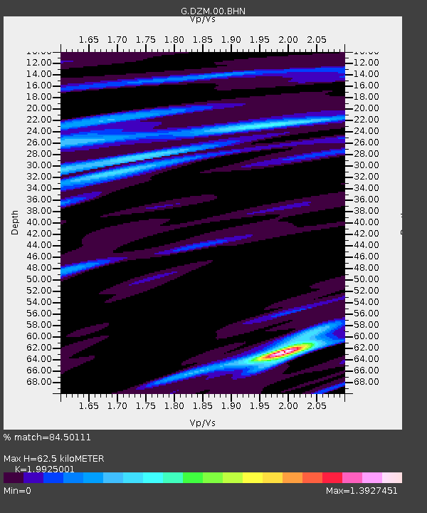
| Estimated Moho Depth: |
62.5 km |
| Estimated Crust Vp/Vs: |
1.99 |
| Assumed Crust Vp: |
5.14 km/s |
| Estimated Crust Vs: |
2.58 km/s |
| Estimated Crust Poisson's Ratio: |
0.33 |
|
| Radial Match: |
84.50111 % |
| Radial Bump: |
400 |
| Transverse Match: |
77.258446 % |
| Transverse Bump: |
400 |
| SOD ConfigId: |
2429771 |
| Insert Time: |
2017-11-14 11:32:02.267 +0000 |
| GWidth: |
2.5 |
| Max Bumps: |
400 |
| Tol: |
0.001 |
|
Signal To Noise
| Channel | StoN | STA | LTA |
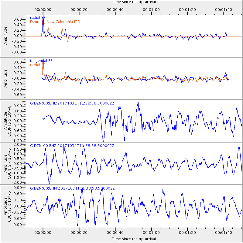
| G:DZM:00:BHZ:20171031T11:38:58.500002Z | 6.6885524 | 1.1460518E-6 | 1.7134526E-7 |
| G:DZM:00:BHN:20171031T11:38:58.500002Z | 0.7598718 | 2.044261E-7 | 2.690271E-7 |
| G:DZM:00:BHE:20171031T11:38:58.500002Z | 3.9544723 | 6.0379284E-7 | 1.5268607E-7 |
| Arrivals |
| Ps | 13 SECOND |
| PpPs | 35 SECOND |
| PsPs/PpSs | 48 SECOND |


