You are here: Home > Network List > G - GEOSCOPE Stations List
> Station NOUC Port Laguerre, New Caledonia > Earthquake Result Viewer
NOUC Port Laguerre, New Caledonia - Earthquake Result Viewer
| Earthquake location: |
Seram, Indonesia |
| Earthquake latitude/longitude: |
-3.8/127.7 |
| Earthquake time(UTC): |
2017/10/31 (304) 11:31:42 GMT |
| Earthquake Depth: |
27 km |
| Earthquake Magnitude: |
5.9 Mww |
| Earthquake Catalog/Contributor: |
NEIC PDE/us |
|
| Network: |
G GEOSCOPE |
| Station: |
NOUC Port Laguerre, New Caledonia |
| Lat/Lon: |
22.10 S/166.30 E |
| Elevation: |
112 m |
|
| Distance: |
41.6 deg |
| Az: |
119.376 deg |
| Baz: |
290.348 deg |
| Ray Param: |
0.07365155 |
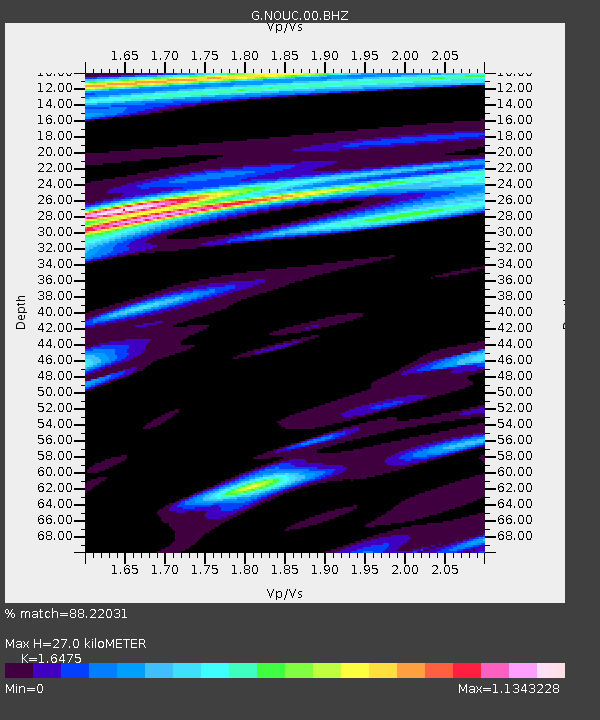
| Estimated Moho Depth: |
27.0 km |
| Estimated Crust Vp/Vs: |
1.65 |
| Assumed Crust Vp: |
5.14 km/s |
| Estimated Crust Vs: |
3.12 km/s |
| Estimated Crust Poisson's Ratio: |
0.21 |
|
| Radial Match: |
88.22031 % |
| Radial Bump: |
349 |
| Transverse Match: |
80.213715 % |
| Transverse Bump: |
400 |
| SOD ConfigId: |
2429771 |
| Insert Time: |
2017-11-14 11:32:06.131 +0000 |
| GWidth: |
2.5 |
| Max Bumps: |
400 |
| Tol: |
0.001 |
|

Signal To Noise
| Channel | StoN | STA | LTA |
| G:NOUC:00:BHZ:20171031T11:38:57.599001Z | 4.735849 | 7.5353773E-7 | 1.5911355E-7 |
| G:NOUC:00:BHN:20171031T11:38:57.599001Z | 2.0068858 | 2.1527444E-7 | 1.072679E-7 |
| G:NOUC:00:BHE:20171031T11:38:57.599001Z | 4.9700427 | 6.4956566E-7 | 1.306962E-7 |
| Arrivals |
| Ps | 3.6 SECOND |
| PpPs | 13 SECOND |
| PsPs/PpSs | 17 SECOND |


