You are here: Home > Network List > US - United States National Seismic Network Stations List
> Station MNTX Cornudas Mountains, Texas, USA > Earthquake Result Viewer
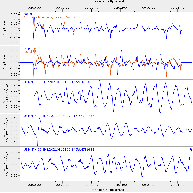
MNTX Cornudas Mountains, Texas, USA - Earthquake Result Viewer
*The percent match for this event was below the threshold and hence no stack was calculated.
| Earthquake location: |
South Of Fiji Islands |
| Earthquake latitude/longitude: |
-25.2/178.4 |
| Earthquake time(UTC): |
2021/03/12 (071) 00:03:19 GMT |
| Earthquake Depth: |
541 km |
| Earthquake Magnitude: |
5.8 mww |
| Earthquake Catalog/Contributor: |
NEIC PDE/us |
|
| Network: |
US United States National Seismic Network |
| Station: |
MNTX Cornudas Mountains, Texas, USA |
| Lat/Lon: |
31.70 N/105.38 W |
| Elevation: |
404 m |
|
| Distance: |
92.1 deg |
| Az: |
55.941 deg |
| Baz: |
241.739 deg |
| Ray Param: |
$rayparam |
*The percent match for this event was below the threshold and hence was not used in the summary stack. |
|
| Radial Match: |
62.352955 % |
| Radial Bump: |
394 |
| Transverse Match: |
74.28407 % |
| Transverse Bump: |
400 |
| SOD ConfigId: |
24334971 |
| Insert Time: |
2021-03-26 00:19:23.681 +0000 |
| GWidth: |
2.5 |
| Max Bumps: |
400 |
| Tol: |
0.001 |
|
Signal To Noise
| Channel | StoN | STA | LTA |
| US:MNTX:00:BHZ:20210312T00:14:59.473983Z | 4.2820854 | 3.7113188E-7 | 8.667082E-8 |
| US:MNTX:00:BH1:20210312T00:14:59.473983Z | 0.88564503 | 4.970929E-8 | 5.612778E-8 |
| US:MNTX:00:BH2:20210312T00:14:59.473983Z | 0.9122498 | 7.614136E-8 | 8.346547E-8 |
| Arrivals |
| Ps | |
| PpPs | |
| PsPs/PpSs | |


