You are here: Home > Network List > UU - University of Utah Regional Network Stations List
> Station KNB Kanab, UT, USA > Earthquake Result Viewer
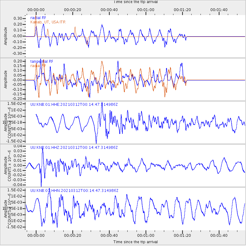
KNB Kanab, UT, USA - Earthquake Result Viewer
*The percent match for this event was below the threshold and hence no stack was calculated.
| Earthquake location: |
South Of Fiji Islands |
| Earthquake latitude/longitude: |
-25.2/178.4 |
| Earthquake time(UTC): |
2021/03/12 (071) 00:03:19 GMT |
| Earthquake Depth: |
541 km |
| Earthquake Magnitude: |
5.8 mww |
| Earthquake Catalog/Contributor: |
NEIC PDE/us |
|
| Network: |
UU University of Utah Regional Network |
| Station: |
KNB Kanab, UT, USA |
| Lat/Lon: |
37.02 N/112.82 W |
| Elevation: |
1715 m |
|
| Distance: |
89.5 deg |
| Az: |
48.263 deg |
| Baz: |
237.66 deg |
| Ray Param: |
$rayparam |
*The percent match for this event was below the threshold and hence was not used in the summary stack. |
|
| Radial Match: |
68.576935 % |
| Radial Bump: |
400 |
| Transverse Match: |
53.166615 % |
| Transverse Bump: |
400 |
| SOD ConfigId: |
24334971 |
| Insert Time: |
2021-03-26 00:19:47.364 +0000 |
| GWidth: |
2.5 |
| Max Bumps: |
400 |
| Tol: |
0.001 |
|
Signal To Noise
| Channel | StoN | STA | LTA |
| UU:KNB:01:HHZ:20210312T00:14:47.314986Z | 3.36666 | 1.6379454E-8 | 4.865194E-9 |
| UU:KNB:01:HHN:20210312T00:14:47.314986Z | 2.7614431 | 8.025211E-9 | 2.9061658E-9 |
| UU:KNB:01:HHE:20210312T00:14:47.314986Z | 1.8267902 | 6.911271E-9 | 3.7832866E-9 |
| Arrivals |
| Ps | |
| PpPs | |
| PsPs/PpSs | |


