You are here: Home > Network List > UW - Pacific Northwest Regional Seismic Network Stations List
> Station LTY Liberty (broad-band) > Earthquake Result Viewer
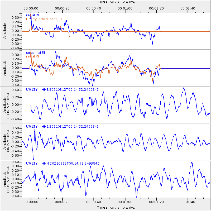
LTY Liberty (broad-band) - Earthquake Result Viewer
*The percent match for this event was below the threshold and hence no stack was calculated.
| Earthquake location: |
South Of Fiji Islands |
| Earthquake latitude/longitude: |
-25.2/178.4 |
| Earthquake time(UTC): |
2021/03/12 (071) 00:03:19 GMT |
| Earthquake Depth: |
541 km |
| Earthquake Magnitude: |
5.8 mww |
| Earthquake Catalog/Contributor: |
NEIC PDE/us |
|
| Network: |
UW Pacific Northwest Regional Seismic Network |
| Station: |
LTY Liberty (broad-band) |
| Lat/Lon: |
47.26 N/120.66 W |
| Elevation: |
970 m |
|
| Distance: |
90.6 deg |
| Az: |
36.547 deg |
| Baz: |
232.396 deg |
| Ray Param: |
$rayparam |
*The percent match for this event was below the threshold and hence was not used in the summary stack. |
|
| Radial Match: |
45.66192 % |
| Radial Bump: |
400 |
| Transverse Match: |
38.311016 % |
| Transverse Bump: |
400 |
| SOD ConfigId: |
24334971 |
| Insert Time: |
2021-03-26 00:20:42.129 +0000 |
| GWidth: |
2.5 |
| Max Bumps: |
400 |
| Tol: |
0.001 |
|
Signal To Noise
| Channel | StoN | STA | LTA |
| UW:LTY: :HHZ:20210312T00:14:52.249984Z | 4.2497854 | 3.425423E-7 | 8.060226E-8 |
| UW:LTY: :HHN:20210312T00:14:52.249984Z | 0.7545142 | 1.01702355E-7 | 1.3479183E-7 |
| UW:LTY: :HHE:20210312T00:14:52.249984Z | 0.930373 | 1.5680239E-7 | 1.6853711E-7 |
| Arrivals |
| Ps | |
| PpPs | |
| PsPs/PpSs | |


