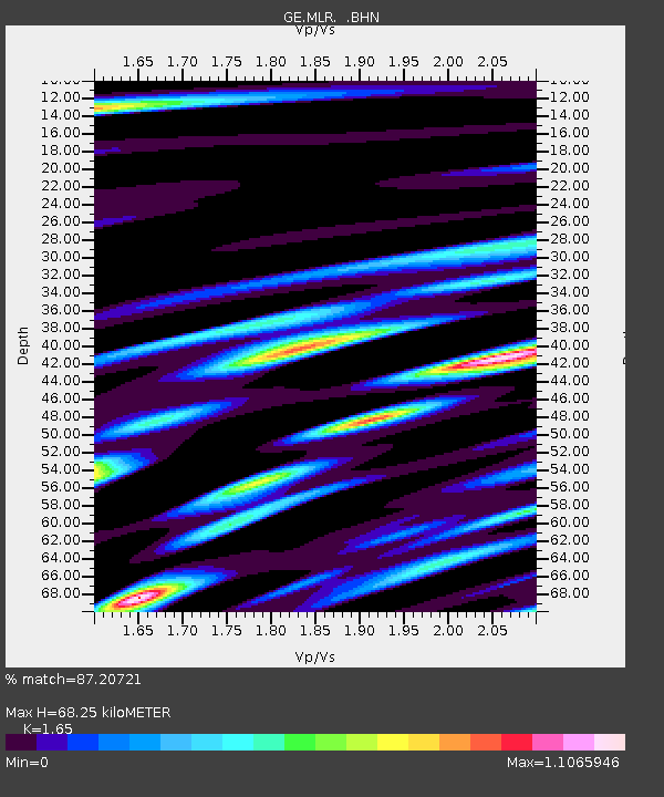
MLR GEOFON Station Muntele Rosu, Romania - Earthquake Result Viewer

Earthquake location: Unimak Island Region, Alaska
Earthquake latitude/longitude: 53.6/-163.5
Earthquake time(UTC): 1995/07/08 (189) 17:15:28 GMT
Earthquake Depth: 33 km
Earthquake Magnitude: 5.8 MB, 5.7 MS, 5.5 UNKNOWN, 6.0 MW
Earthquake Catalog/Contributor: WHDF/NEIC
Network: GE GEOFON
Station: MLR GEOFON Station Muntele Rosu, Romania
Lat/Lon: 45.49 N/25.95 E
Elevation: 1378 m
Distance: 80.9 deg
Az: 353.254 deg
Baz: 5.706 deg
Ray Param: 0.047914527
Estimated Moho Depth: 68.25 km
Estimated Crust Vp/Vs: 1.65
Assumed Crust Vp: 6.194 km/s
Estimated Crust Vs: 3.754 km/s
Estimated Crust Poisson's Ratio: 0.21
Radial Match: 87.20721 %
Radial Bump: 400
Transverse Match: 74.20746 %
Transverse Bump: 400
SOD ConfigId: 6273
Insert Time: 2010-03-09 06:24:05.625 +0000
GWidth: 2.5
Max Bumps: 400
Tol: 0.001

Signal To Noise

ChannelStoNSTALTA
GE:MLR: :BHN:19950708T17:27:07.865015Z4.7005872.893408E-76.155419E-8
GE:MLR: :BHE:19950708T17:27:07.865015Z1.17555342.0141633E-71.7133745E-7
GE:MLR: :BHZ:19950708T17:27:07.865015Z8.1420057.627281E-79.367817E-8
Arrivals
Ps7.4 SECOND
PpPs28 SECOND
PsPs/PpSs36 SECOND