You are here: Home > Network List > GE - GEOFON Stations List
> Station MLR GEOFON Station Muntele Rosu, Romania > Earthquake Result Viewer
MLR GEOFON Station Muntele Rosu, Romania - Earthquake Result Viewer
| Earthquake location: |
Myanmar-India Border Region |
| Earthquake latitude/longitude: |
25.0/95.3 |
| Earthquake time(UTC): |
1995/05/06 (126) 01:59:07 GMT |
| Earthquake Depth: |
122 km |
| Earthquake Magnitude: |
6.4 MB, 6.5 UNKNOWN, 6.4 MW |
| Earthquake Catalog/Contributor: |
WHDF/NEIC |
|
| Network: |
GE GEOFON |
| Station: |
MLR GEOFON Station Muntele Rosu, Romania |
| Lat/Lon: |
45.49 N/25.95 E |
| Elevation: |
1378 m |
|
| Distance: |
58.4 deg |
| Az: |
309.401 deg |
| Baz: |
85.376 deg |
| Ray Param: |
0.062479373 |
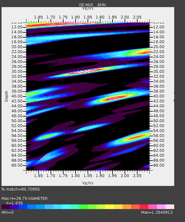
| Estimated Moho Depth: |
29.75 km |
| Estimated Crust Vp/Vs: |
1.84 |
| Assumed Crust Vp: |
6.194 km/s |
| Estimated Crust Vs: |
3.376 km/s |
| Estimated Crust Poisson's Ratio: |
0.29 |
|
| Radial Match: |
90.70955 % |
| Radial Bump: |
400 |
| Transverse Match: |
91.2385 % |
| Transverse Bump: |
400 |
| SOD ConfigId: |
6273 |
| Insert Time: |
2010-03-09 06:24:19.876 +0000 |
| GWidth: |
2.5 |
| Max Bumps: |
400 |
| Tol: |
0.001 |
|

Signal To Noise
| Channel | StoN | STA | LTA |
| GE:MLR: :BHN:19950506T02:08:19.830017Z | 12.167337 | 6.612358E-7 | 5.4345147E-8 |
| GE:MLR: :BHE:19950506T02:08:19.830017Z | 14.563895 | 1.0679831E-6 | 7.333087E-8 |
| GE:MLR: :BHZ:19950506T02:08:19.830017Z | 57.697777 | 4.489771E-6 | 7.781532E-8 |
| Arrivals |
| Ps | 4.2 SECOND |
| PpPs | 13 SECOND |
| PsPs/PpSs | 17 SECOND |


