You are here: Home > Network List > AV - Alaska Volcano Observatory Stations List
> Station MAPS Pakushin Southeast, Makushin Volcano, Alaska > Earthquake Result Viewer
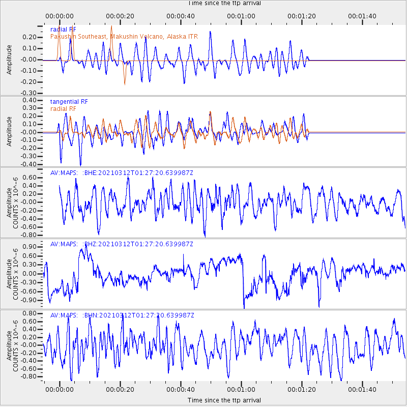
MAPS Pakushin Southeast, Makushin Volcano, Alaska - Earthquake Result Viewer
*The percent match for this event was below the threshold and hence no stack was calculated.
| Earthquake location: |
Irian Jaya, Indonesia |
| Earthquake latitude/longitude: |
-4.7/138.4 |
| Earthquake time(UTC): |
2021/03/12 (071) 01:16:16 GMT |
| Earthquake Depth: |
10 km |
| Earthquake Magnitude: |
5.4 Mww |
| Earthquake Catalog/Contributor: |
NEIC PDE/us |
|
| Network: |
AV Alaska Volcano Observatory |
| Station: |
MAPS Pakushin Southeast, Makushin Volcano, Alaska |
| Lat/Lon: |
53.81 N/166.94 W |
| Elevation: |
333 m |
|
| Distance: |
74.0 deg |
| Az: |
30.231 deg |
| Baz: |
237.788 deg |
| Ray Param: |
$rayparam |
*The percent match for this event was below the threshold and hence was not used in the summary stack. |
|
| Radial Match: |
40.92775 % |
| Radial Bump: |
400 |
| Transverse Match: |
59.03209 % |
| Transverse Bump: |
400 |
| SOD ConfigId: |
24334971 |
| Insert Time: |
2021-03-26 01:32:38.759 +0000 |
| GWidth: |
2.5 |
| Max Bumps: |
400 |
| Tol: |
0.001 |
|
Signal To Noise
| Channel | StoN | STA | LTA |
| AV:MAPS: :BHZ:20210312T01:27:20.639987Z | 3.7912538 | 6.7093305E-7 | 1.7696864E-7 |
| AV:MAPS: :BHN:20210312T01:27:20.639987Z | 1.8651352 | 4.6907053E-7 | 2.5149413E-7 |
| AV:MAPS: :BHE:20210312T01:27:20.639987Z | 0.9568336 | 2.773693E-7 | 2.898825E-7 |
| Arrivals |
| Ps | |
| PpPs | |
| PsPs/PpSs | |


